Redange
| Redange Réiden | ||
|---|---|---|
| Commune | ||
|
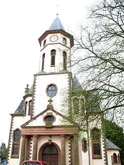
Redange church | ||
| ||
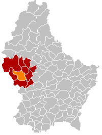 Map of Luxembourg with Redange highlighted in orange, and the canton in dark red | ||
| Coordinates: 49°45′55″N 5°53′22″E / 49.765203°N 5.889355°ECoordinates: 49°45′55″N 5°53′22″E / 49.765203°N 5.889355°E | ||
| Country |
| |
| Canton | Redange | |
| Government | ||
| • Mayor | Henri Mausen | |
| Area | ||
| • Total | 31.95 km2 (12.34 sq mi) | |
| Area rank | 20 of 105 | |
| Highest elevation | 493 m (1,617 ft) | |
| • Rank | 21st of 105 | |
| Lowest elevation | 253 m (830 ft) | |
| • Rank | 59th of 105 | |
| Population (2014) | ||
| • Total | 2,631 | |
| • Rank | 51st of 105 | |
| • Density | 82/km2 (210/sq mi) | |
| • Density rank | 69th of 105 | |
| Time zone | CET (UTC+1) | |
| • Summer (DST) | CEST (UTC+2) | |
| LAU 2 | LU00003006 | |
| Website | redange.lu | |

Redange or Redange-sur-Attert (Luxembourgish: Réiden, German: Redingen) is a commune and town in western Luxembourg, near the border with Belgium. It is the capital of the canton of Redange. Redange is situated on the river Attert, a tributary of the Alzette.
As of 2005, the town of Redange, which lies in the west of the commune, has a population of 1,099. Other towns within the commune include Lannen, Nagem, Niederpallen, Ospern, and Reichlange.
Redange is the birthplace of Luxembourg's former Prime Minister, Jean-Claude Juncker.
External links
-
 Media related to Redange at Wikimedia Commons
 |
Rambrouch | Préizerdaul | | |
| Ell | |
Useldange | ||
| ||||
| | ||||
| Beckerich |
 | ||
This article is issued from Wikipedia - version of the 12/1/2016. The text is available under the Creative Commons Attribution/Share Alike but additional terms may apply for the media files.