Radmer
| Radmer | |
|---|---|
 Radmer Location within Austria | |
| Coordinates: 47°32′42″N 14°45′28″E / 47.54500°N 14.75778°ECoordinates: 47°32′42″N 14°45′28″E / 47.54500°N 14.75778°E | |
| Country | Austria |
| State | Styria |
| District | Leoben |
| Government | |
| • Mayor | Ludwig Gottsbacher (SPÖ) |
| Area | |
| • Total | 82.42 km2 (31.82 sq mi) |
| Elevation | 729 m (2,392 ft) |
| Population (1 January 2016)[1] | |
| • Total | 590 |
| • Density | 7.2/km2 (19/sq mi) |
| Time zone | CET (UTC+1) |
| • Summer (DST) | CEST (UTC+2) |
| Postal code | 8795 |
| Area code | 03635 |
| Vehicle registration | LN |
| Website | www.radmer.at |
Radmer is a municipality in the district of Leoben in Austrian state of Styria.
Population
| Historical population | ||
|---|---|---|
| Year | Pop. | ±% |
| 1869 | 882 | — |
| 1880 | 927 | +5.1% |
| 1890 | 937 | +1.1% |
| 1900 | 914 | −2.5% |
| 1910 | 908 | −0.7% |
| 1923 | 1,032 | +13.7% |
| 1934 | 904 | −12.4% |
| 1939 | 1,010 | +11.7% |
| 1951 | 986 | −2.4% |
| 1961 | 1,178 | +19.5% |
| 1971 | 1,160 | −1.5% |
| 1981 | 1,006 | −13.3% |
| 1991 | 903 | −10.2% |
| 2001 | 794 | −12.1% |
| 2011 | 678 | −14.6% |
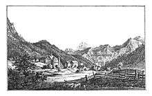
Castle Greifenberg, 1830, Lith. J.F. Kaiser, Graz
References
This article is issued from Wikipedia - version of the 1/4/2015. The text is available under the Creative Commons Attribution/Share Alike but additional terms may apply for the media files.