Schleißheim
This article describes a municipality in Austria. For the Bavarian palace, see: Schleißheim Palace. For northern suburbs of Munich, see: Oberschleißheim and Unterschleißheim.
| Schleißheim | ||
|---|---|---|
|
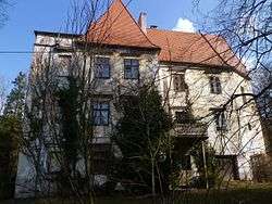
Dietach palace | ||
| ||
 Schleißheim Location within Austria | ||
| Coordinates: 48°09′39″N 14°05′36″E / 48.16083°N 14.09333°ECoordinates: 48°09′39″N 14°05′36″E / 48.16083°N 14.09333°E | ||
| Country | Austria | |
| State | Upper Austria | |
| District | Wels-Land | |
| Government | ||
| • Mayor | Manfred Zauner (ÖVP) | |
| Area | ||
| • Total | 7.55 km2 (2.92 sq mi) | |
| Elevation | 317 m (1,040 ft) | |
| Population (14 June 2016)[1] | ||
| • Total | 1,312 | |
| • Density | 170/km2 (450/sq mi) | |
| Time zone | CET (UTC+1) | |
| • Summer (DST) | CEST (UTC+2) | |
| Postal code | 4600 | |
| Area codes | 0 72 42 | |
| Vehicle registration | WL | |
| Website | www.schleissheim.at | |
Schleißheim is a municipality in the district Wels-Land in the Austrian state of Upper Austria.
Population
| Historical population | ||
|---|---|---|
| Year | Pop. | ±% |
| 1869 | 568 | — |
| 1880 | 565 | −0.5% |
| 1890 | 566 | +0.2% |
| 1900 | 532 | −6.0% |
| 1910 | 538 | +1.1% |
| 1923 | 568 | +5.6% |
| 1934 | 644 | +13.4% |
| 1939 | 613 | −4.8% |
| 1951 | 711 | +16.0% |
| 1961 | 590 | −17.0% |
| 1971 | 611 | +3.6% |
| 1981 | 749 | +22.6% |
| 1991 | 845 | +12.8% |
| 2001 | 938 | +11.0% |
| 2011 | 1,233 | +31.4% |
References
| Wikimedia Commons has media related to Schleißheim. |
This article is issued from Wikipedia - version of the 3/7/2014. The text is available under the Creative Commons Attribution/Share Alike but additional terms may apply for the media files.