Podkraj pri Velenju
| Podkraj pri Velenju | |
|---|---|
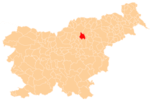
 Podkraj pri Velenju Location in Slovenia | |
| Coordinates: 46°20′59.87″N 15°5′6.86″E / 46.3499639°N 15.0852389°ECoordinates: 46°20′59.87″N 15°5′6.86″E / 46.3499639°N 15.0852389°E | |
| Country |
|
| Traditional region | Styria |
| Statistical region | Savinja |
| Municipality | Velenje |
| Area | |
| • Total | 3.43 km2 (1.32 sq mi) |
| Elevation | 510.6 m (1,675.2 ft) |
| Population (2002) | |
| • Total | 626 |
| [1] | |
Podkraj pri Velenju (pronounced [pɔtˈkɾai̯ pɾi ʋɛˈlɛːnju]) is a settlement in the Municipality of Velenje in northern Slovenia. It lies in the Ložnica Hills (Slovene: Ložničko gričevje) southwest of the town of Velenje. The area was traditionally part of Styria. The entire municipality is now included in the Savinja Statistical Region.[2]
Name
The name of the settlement was changed from Podkraj to Podkraj pri Velenju in 1955.[3]
Church
The local church is dedicated to Saint James (Slovene: sveti Jakob) and belongs to the Parish of Velenje–Saint Mary. It dates to the late 16th century and was rebuilt in the 17th and 18th centuries.[4]
References
- ↑ Statistical Office of the Republic of Slovenia
- ↑ Velenje municipal site
- ↑ Spremembe naselij 1948–95. 1996. Database. Ljubljana: Geografski inštitut ZRC SAZU, DZS.
- ↑ Slovenian Ministry of Culture register of national heritage reference number ešd 3405
External links
| Settlements | Administrative Centre: Velenje
|  | ||||||
|---|---|---|---|---|---|---|---|---|
| Landmarks |
| |||||||
| Notable people |
| |||||||
This article is issued from Wikipedia - version of the 10/22/2016. The text is available under the Creative Commons Attribution/Share Alike but additional terms may apply for the media files.