Pirapora do Bom Jesus
| Pirapora do Bom Jesus | |
|---|---|
| Municipality | |
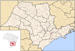 Location in São Paulo state | |
 Pirapora do Bom Jesus Location in Brazil | |
| Coordinates: 23°23′50″S 47°0′10″W / 23.39722°S 47.00278°WCoordinates: 23°23′50″S 47°0′10″W / 23.39722°S 47.00278°W | |
| Country |
|
| Region | Southeast Brazil |
| State | São Paulo |
| Metropolitan Region | São Paulo |
| Area | |
| • Total | 108.49 km2 (41.89 sq mi) |
| Population (2015) | |
| • Total | 17,646 |
| • Density | 160/km2 (420/sq mi) |
| Time zone | BRT (UTC-3) |
| • Summer (DST) | BRST (UTC-2) |
Pirapora do Bom Jesus is a municipality in the state of São Paulo in Brazil. It is part of the Metropolitan Region of São Paulo.[1] The population is 17,646 (2015 est.) in an area of 108.49 km².[2] The name Pirapora comes from the Tupi language.
See also
References
 |
Cabreúva and Jundiaí | | ||
| Araçariguama | |
Cajamar | ||
| ||||
| | ||||
| Santana de Parnaíba |
This article is issued from Wikipedia - version of the 5/14/2016. The text is available under the Creative Commons Attribution/Share Alike but additional terms may apply for the media files.