Pangsha Upazila
| Pangsha পাংশা | |
|---|---|
| Upazila | |
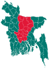
 Pangsha Location in Bangladesh | |
| Coordinates: 23°47.5′N 89°25′E / 23.7917°N 89.417°ECoordinates: 23°47.5′N 89°25′E / 23.7917°N 89.417°E | |
| Country |
|
| Division | Dhaka Division |
| District | Rajbari District |
| Area | |
| • Total | 414.24 km2 (159.94 sq mi) |
| Population (1991) | |
| • Total | 316,752 |
| • Density | 760/km2 (2,000/sq mi) |
| Time zone | BST (UTC+6) |
| Website | Official Map of Pangsha |
Pangsha (Bengali: পাংশা) is an Upazila of Rajbari District[1] in the Division of Dhaka, Bangladesh.
Geography
Pangsha is located at 23°47′30″N 89°25′00″E / 23.7917°N 89.4167°E . It has 54,424 households and a total area of 414.24 km².
Demographics
According to the 1991 Bangladesh census, Pangsha had a population of 316,752, of whom 151,566 were aged 18 or older. Males constituted 51.78% of the population, and females 48.22%. Pangsha had an average literacy rate of 23.1% (7+ years), against the national average of 32.4%.[2] mashhpara 23.75/89.36. Bagduli High School. Pangsha Rajbari Maurat latitude 23.47 longitude89,25
Administration
Pangsha has 20 Unions/Wards, 359 Mauzas/Mahallas, and 316 villages.
Gallery
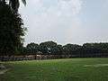 Pangsha Govt. College Campus.
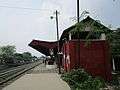 Pangsha Railway Station.
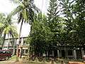 Pangsha Upazila Complex building.
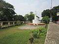 The 1971 war monument at Pangsha Upazila
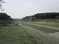 Chandana River at Pangsha.
See also
References
- ↑ Md. Tawhid Mia (2012), "Pangsha Upazila", in Sirajul Islam and Ahmed A. Jamal, Banglapedia: National Encyclopedia of Bangladesh (Second ed.), Asiatic Society of Bangladesh
- ↑ "Population Census Wing, BBS.". Archived from the original on 2005-03-27. Retrieved November 10, 2006.
| Upazila/Thana: | ||
|---|---|---|
This article is issued from Wikipedia - version of the 11/10/2016. The text is available under the Creative Commons Attribution/Share Alike but additional terms may apply for the media files.