Palamu district
| Palamu district पलामू ज़िला | |
|---|---|
| District of Jharkhand | |
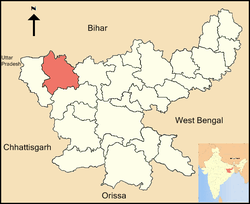 Location of Palamu district in Jharkhand | |
| Country | India |
| State | Jharkhand |
| Administrative division | Palamu |
| Headquarters | Daltonganj |
| Government | |
| • Lok Sabha constituencies | 1. Palamu, 2. Chatra (shared with Chatra district) |
| • Assembly seats | 5 |
| Area | |
| • Total | 5,044 km2 (1,947 sq mi) |
| Major highways | NH 75, NH 98 |
| Website | Official website |
Palamau is one of the twenty-four districts of Jharkhand state, India. It was formed in 1892. The administrative headquarter of the district is Daltonganj, situated on the Koel River.
Geography
The district lies between 23°50′ and 24°8′ north latitude and between 83°55′ and 84°30′ east longitude. It is bordered on the north by Sone River & Bihar and on the east by the Chatra and Hazaribagh districts, on the south by Latehar District and on the west by Garhwa District.
National protected area
Administration
Blocks/Mandals
Palamu district consists of 21 Blocks. The following are the list of the Blocks in Palamu district:
- Bishrampur block
- Chainpur block
- Chatarpur block
- Medininagar block
- Haidernagar block
- Hariharganj block
- Hussainabad block
- Lesliganj block
- Manatu block
- Mohammadganj block
- Naudiha Bazar block
- Nawa Bazar block
- Padwa block
- Pandu block
- Panki block
- Patan block
- Pipra block
- Satbarwa block
- Tarhasi block
- Untari Road block
- Ramgarh
Economy
In 2006 the Ministry of Panchayati Raj named Palamu one of the country's 250 most backward districts (out of a total of 640).[1] It is one of the 24 districts in Jharkhand currently receiving funds from the Backward Regions Grant Fund Programme (BRGF).[1]
Demographics
According to the 2011 census Palamu district has a population of 24,36,319,[2] roughly equal to the nation of Lesotho[3] or the US state of West Virginia.[4] This gives it a ranking of 243rd in India (out of a total of 640).[2] The district has a population density of 381 inhabitants per square kilometre (990/sq mi) .[2] Its population growth rate over the decade 2001-2011 was 25.94%.[2] Palamu has a sex ratio of 929 females for every 1000 males,[2] and a literacy rate of 65.5%.[2]
Languages
Languages spoken here include Asuri, an Austroasiatic language spoken by approximately 17 000 in India, largely in the southern part of Palamu;[5] and [Magahi Language] group with almost 40 000 000 speakers, written in both the Devanagari and Kaithi scripts.[6]
Education
The only university in Medininagar (Daltonganj) is Nilamber-Pitamber University, created on the 17th of January, 2009.[7][8] The Chief Minister of Jharkhand declared that the Nilamber-Pitamber University would be set up in Medininagar (Daltonganj) in 2001.[9] There are 66 primary schools, 30 middle schools, 17 Navsirijit schools, 10 high schools and 1 Engineering College in the Daltonganj block.[10]
See also
References
- 1 2 Ministry of Panchayati Raj (September 8, 2009). "A Note on the Backward Regions Grant Fund Programme" (PDF). National Institute of Rural Development. Retrieved September 27, 2011.
- 1 2 3 4 5 6 "District Census 2011". Census2011.co.in. 2011. Retrieved 2011-09-30.
- ↑ US Directorate of Intelligence. "Country Comparison:Population". Retrieved 2011-10-01.
Lesotho 24,24,886
- ↑ "2010 Resident Population Data". U. S. Census Bureau. Retrieved 2011-09-30.
West Virginia 1,852,994
- ↑ M. Paul Lewis, ed. (2009). "Asuri: A language of India". Ethnologue: Languages of the World (16th ed.). Dallas, Texas: SIL International. Retrieved 2011-09-28.
- ↑ M. Paul Lewis, ed. (2009). "Bhojpuri: A language of India". Ethnologue: Languages of the World (16th ed.). Dallas, Texas: SIL International. Retrieved 2011-09-30.
- ↑ http://articles.timesofindia.indiatimes.com/2013-02-03/ranchi/36720999_1_nilamber-pitamber-university-land-acquisition-process-firoz-ahmad
- ↑ "Nilamber-Pitamber University". Retrieved December 27, 2012.
- ↑ "Chapter IX: Social Services". Jharkhand Draft Annual Plan 2001 - 2002. Retrieved 2007-07-10. Archived March 12, 2005, at the Wayback Machine.
- ↑ "Palamu District: Education Profile". Retrieved 2007-07-10.
External links
 |
Rohtas district, Bihar | Aurangabad district, Bihar | Gaya district, Bihar | |
| Garhwa district | |
Chatra district | ||
| ||||
| | ||||
| Latehar district |
Coordinates: 24°01′48″N 84°04′12″E / 24.03000°N 84.07000°E