Oriava
| Oriava Орява | |
|---|---|
| village | |
|
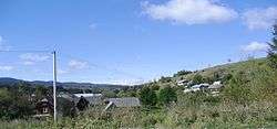
The general view of village Oriava. | |
 Oriava | |
| Coordinates: UA 48°55′18″N 23°17′44″E / 48.92167°N 23.29556°ECoordinates: UA 48°55′18″N 23°17′44″E / 48.92167°N 23.29556°E | |
| Country |
|
| Province |
|
| District |
|
| Established | 1574 |
| Area | |
| • Total | 3,3 km2 (13 sq mi) |
| Elevation/(average value of) | 671 m (2,201 ft) |
| Population | |
| • Total | 523 |
| • Density | 191,82/km2 (49,680/sq mi) |
| Time zone | EET (UTC+2) |
| • Summer (DST) | EEST (UTC+3) |
| Postal code | 82640 |
| Area code | +380 3251 |
| Website | село Орява (Ukrainian) |
Oriava (Ukrainian: Оря́ва[1]) is a village (selo) in Skole Raion, Lviv Oblast, of Western Ukraine. Village Oriava is located in the Ukrainian Carpathians within the limits the Eastern Beskids ( Skole Beskids ) in southern Lviv Oblast. The village is located along the river with the same name Oriava.[2]
It is 133 kilometres (83 mi) from the city of Lviv, 61 kilometres (38 mi) from Stryi, and 24 kilometres (15 mi) from Skole.
Local government– Oriavska village council.[3]
The first mention of Oriava dates from the year 1574.[4]
Attractions
_1882._Oriava.JPG)
Church of the Nativity Blessed Virgin Mary (wood) 1882
The village has an architectural monument of local importance of Skole Raion (Skole district).[5]
- Church of the Nativity Blessed Virgin Mary (wood) 1882 (the previous name - Church of St. Arch. Michael).
References
- ↑ Оря́ва, вікіпедія Ukrainian:
- ↑ Oriava Ukrainian:
- ↑ Орявська сільська рада (Ukrainian)
- ↑ (Ukrainian)
- ↑ Пам'ятки архітектури Сколівського району Ukrainian:
External links
- Ukrainian: Населенні пункти Сколівського району - Орява
- Ukrainian: Сколівщина.-Львів.1996
- weather.in.ua
| Cities | ||
|---|---|---|
| Urban-type settlements | ||
| Villages |
| |
This article is issued from Wikipedia - version of the 7/12/2016. The text is available under the Creative Commons Attribution/Share Alike but additional terms may apply for the media files.