Oirase River
| Oirase River | |
|---|---|
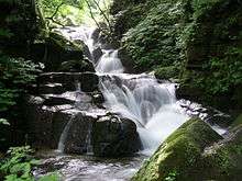 Oirase River gorge | |
| Native name | 奥入瀬川 |
| Basin | |
| Main source |
Lake Towada, Aomori & Akita Prefectures, Japan 401 m (1,316 ft) |
| River mouth |
Pacific Ocean 0 m (0 ft) |
| Basin size | 820 km2 (320 sq mi) |
| Physical characteristics | |
| Length | 67 km (42 mi) |
The Oirase River (奥入瀬川 Oirase-gawa) is a river located in eastern Aomori prefecture, Japan.
The Oirase River is the only river draining Lake Towada, a large caldera lake on the border of Aomori and Akita Prefectures. The river flows in a generally eastern direction, through the municipalities of Towada, Rokunohe, Oirase and Hachinohe before exiting into the Pacific Ocean. The upper reaches of the river form a scenic gorge with numerous rapids and waterfalls, and is one of the major tourist attractions of the Towada-Hachimantai National Park. The lower reaches of the river are used extensively for irrigation.
See also
External links
| Wikimedia Commons has media related to Oirase River. |
40°36′18″N 141°27′48″E / 40.604937°N 141.463306°ECoordinates: 40°36′18″N 141°27′48″E / 40.604937°N 141.463306°E (river mouth)
This article is issued from Wikipedia - version of the 6/19/2016. The text is available under the Creative Commons Attribution/Share Alike but additional terms may apply for the media files.