Nur al-Din Mosque
| Nur Al-Din Mosque جامع نور الدين | |
|---|---|
|
The minaret of Nur al-Din Mosque | |
| Basic information | |
| Location |
|
| Geographic coordinates | 35°8′6″N 36°45′9″E / 35.13500°N 36.75250°ECoordinates: 35°8′6″N 36°45′9″E / 35.13500°N 36.75250°E |
| Affiliation | Islam |
| Region | Levant |
| Status | Active |
| Architectural description | |
| Architectural type | Mosque |
| Architectural style | Zengid |
| Completed | 1172 |
| Specifications | |
| Minaret(s) | 1 |
| Materials | Basalt, Limestone, Tiles |
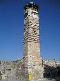
The Nur Al-Din Mosque (Arabic: جامع نور الدين, transliteration: Jami Nur al-Din) is a Zengid-era mosque in Hama, Syria.[1]
The mosque was profoundly damaged in the 1982 shelling of the city and subsequently restored to its current state.

Prior to 1982 shelling
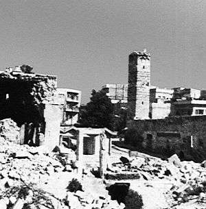
After shelling
References
- ↑ Nur al-Din Mosque Archnet Digital Library.
Bibliography
- Rihawi, Abdul Qader (1979). Arabic Islamic Architecture: Its Characteristics and Traces in Syria. Publications of the Ministry of Culture and National Leadership.


This article is issued from Wikipedia - version of the 9/20/2016. The text is available under the Creative Commons Attribution/Share Alike but additional terms may apply for the media files.