Neeltje Jans
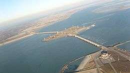 Northern section of the flood barrier, with part of Neeltje Jans in the right bottom corner, the partial shoal Roggenplaat in the center. | |
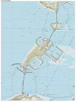 Topographical map of the Oosterscheldedam. Neeltje Jans is the large island structure in the centre. | |
| Geography | |
|---|---|
| Location | Eastern Scheldt |
| Coordinates | 51°37′37″N 3°42′01″E / 51.62694°N 3.70028°ECoordinates: 51°37′37″N 3°42′01″E / 51.62694°N 3.70028°E |
| Administration | |
| Province | Zeeland |
| Municipality | Veere |
| Additional information | |
| Official website |
www |
Neeltje Jans (Dutch pronunciation: [ˈneːltjə jɑns]) is an artificial island in the Netherlands in the province of Zeeland, halfway between Noord-Beveland and Schouwen-Duiveland in the Oosterschelde. It was constructed to facilitate the construction of the Oosterscheldedam.
After the construction a fun park with attractions and various expositions was built on the island, now connected to the shore through the dam. In addition part of the island is a nature reserve.[1]
The island was named after a nearby sand bank. The name of this sandbank has two possible origins:[2]
- It could be named after a boat with the name Neeltje Jans, stranded on the sandbank. Neeltje is a Dutch first name (a diminutive from Cornelia or Neelie like in Neelie Kroes). Jans is a familiar surname (meaning a son or daughter of Jan).
- It could be named after a goddess of the sea, Nehalennia.
The second stage of the 2015 Tour de France finished on Neeltje Jans on 5 July 2015.[3]
References
- ↑ Natuurmonumenten
- ↑ Holland museums
- ↑ "Tweede etappe Tour 2015 finisht op Neeltje Jans" (in Dutch). cyclingonline.nl. 24 May 2014. Retrieved 24 May 2014.
External links
- (Dutch) (English) (German) Official web site
-
 Media related to Neeltje Jans at Wikimedia Commons