Nanzih Export Processing Zone Station
Nanzih Export Processing Zone 楠梓加工區 | |
|---|---|
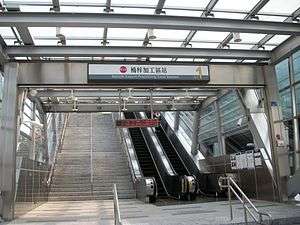 Nanzih Export Processing Zone Station Exit 1 | |
| Location |
Nanzih, Kaohsiung Taiwan |
| Operated by | |
| Line(s) |
|
| Platforms | One Island platform |
| Construction | |
| Structure type | Elevated |
| History | |
| Opened | March 9, 2008 |
| Traffic | |
| Passengers | 5,520 daily (Jan. 2011)[1] |
| Nanzih Export Processing Zone Station | |||||||||||
| Traditional Chinese | 楠梓加工區車站 | ||||||||||
|---|---|---|---|---|---|---|---|---|---|---|---|
| Simplified Chinese | 楠梓加工区车站 | ||||||||||
| |||||||||||
The Kaohsiung MRT Nanzih Export Processing Zone Station is a station on the Red Line in Nanzih District, Kaohsiung, Taiwan.
Station overview
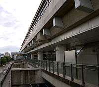
Side view of the Nanzih Export Processing Zone Station Concourse
The station is a three-level, elevated station with one island platforms and six exits.[2] It is 170 meters long and is located on Jiachang Houchang Rd. in front of the Nanzih Export Processing Zone.[3]
Station layout
| 3F | Platform 1 | ← KMRT Red Line toward Siaogang (Oil Refinery Elementary School) |
| Platform 2 | → KMRT Red Line toward Gangshan South (Houjing) → | |
| 2F | Concourse | Lobby, information desk, automatic ticket machines, one-way faregates, Restrooms (Near Exit 4) |
| 1F | ||
| Street Level | Entrance/Exit | |
Exits
- Exit 1: Main gate of the Nanzih Export Processing Zone

- Exit 2: East side of Jiachang Rd.
- Exit 3: East side of Jiachang Rd.
- Exit 4: East side of Jiachang Rd. (Hongyi New Village)
- Exit 5: West side of Jiachang Rd.
- Exit 6: West side of Jiachang Rd.
Around the Station
- Youchang Forest Park
- Nanzih Export Processing Zone
- Kaohsiung Refinery dormitory
- Jiachang Rd.
Nearby stations
| Preceding station | Kaohsiung MRT | Following station | ||
|---|---|---|---|---|
toward Gangshan South | Red Line | toward Siaogang |
References
| Wikimedia Commons has media related to Nanzih Export Processing Zone Station. |
- ↑ "統計資訊 > 統計月報". Transportation Bureau, Kaohsiung City Government. Retrieved 2011-02-15.
- ↑ "楠梓加工區站". 高雄捷運公司. Retrieved 2010-07-10.
- ↑ "楠梓加工區站週邊地圖". 高雄市政府捷運工程局. Retrieved 2010-07-10.
Coordinates: 22°43′08″N 120°18′26″E / 22.71889°N 120.30722°E
This article is issued from Wikipedia - version of the 10/20/2016. The text is available under the Creative Commons Attribution/Share Alike but additional terms may apply for the media files.