Muckle Roe
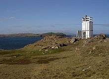
Muckle Roe Lighthouse
Swarbacks Minn|
Muckle Roe Lighthouse |
| Coordinates |
60°20′57″N 1°27′03″W / 60.349232°N 1.450732°W / 60.349232; -1.450732 |
|---|
| Year first constructed |
1897 (first) |
|---|
| Year first lit |
2001 (current) |
|---|
| Deactivated |
2001 (first) |
|---|
| Foundation |
concrete basement |
|---|
| Construction |
metal skeletal tower (current)
cast iron tower (first) |
|---|
| Tower shape |
square parallelepiped tower covered by aluminium panels with light on the top (current)
octagonal prism tower with balcony and lantern |
|---|
| Markings / pattern |
white tower |
|---|
| Height |
7 metres (23 ft) (current)
8 metres (26 ft) (first) |
|---|
| Focal height |
30 metres (98 ft) (current) |
|---|
| Original lens |
3rd order Fresnel lens (first) |
|---|
| Light source |
solar power (current) |
|---|
| Characteristic |
Fl WR 3s.[8] |
|---|
| Admiralty number |
A3844 |
|---|
| NGA number |
3552 |
|---|
| ARLHS number |
SCO-141 |
|---|
| Managing agent |
Northern Lighthouse Board[9] |
|---|
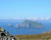
Muckle Roe is an island in Shetland, Scotland, in St. Magnus Bay, to the west of Mainland, Shetland. It has a population of around 130 people, who mainly croft and live in the south east of the island.[7][10]
History
The island is referred to in the Orkneyinga saga.[11]
In 1905 a bridge was built between Muckle Roe and the Shetland Mainland over Roe Sound at a cost of £1,020 met from public subscription and a grant from the Congested Districts Board. The construction was of iron and concrete[7][12] and its completion was followed by a reversal in the population decline seen in the 19th and earlier 20th centuries. A replacement bridge was built in 1999.
Geography and geology
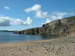
Muckle Roe is approximately 3 miles (4.8 km) in diameter, with high cliffs in the south. Its highest point is Mid Ward 172 metres (564 ft).
The island's rock is red granite,[10] which gives the island its name - a combination of Scots and Old Norse meaning "big red island".[5][7]
There are crofts in the east and south east. The rest of the island is lochan-studded moorland.[13]
Population
Muckle Roe population
| 1851 | 290 |
| 1871 | 216 |
| 1881 | 230 |
| 1961 | 103 |
| 1971 | 94 |
| 1981 | 101 |
| 1991 | 115 |
| 2001 | 104 |
| 2011 | 130 |
| source: [4][5] |
|
See also
Notes
- ↑ Waugh (2007) p. 541
- 1 2 Area and population ranks: there are c. 300 islands over 20 ha in extent and 93 permanently inhabited islands were listed in the 2011 census.
- 1 2 Ordnance Survey. Get-a-map (Map). 1:25,000. Leisure. Ordinance Survey. Retrieved 21 August 2013.
- 1 2 3 National Records of Scotland (15 August 2013) (pdf) Statistical Bulletin: 2011 Census: First Results on Population and Household Estimates for Scotland - Release 1C (Part Two). "Appendix 2: Population and households on Scotland’s inhabited islands". Retrieved 17 August 2013.
- 1 2 3 4 Haswell-Smith (2004) p. 406
- ↑ Fraser, Allen (2002) The Edinburgh Geologist: Old Norse and Norn names in Shetland. Issue 39 Retrieved 14 April 2007.
- 1 2 3 4 Keay & Keay, (1994) p. 711
- ↑ Muckle Roe marinetraffic.com. Retrieved 31 May 2016
- ↑ Muckle Roe (Swarbacks Minn) The Lighthouse Directory. University of North Carolina at Chapel Hill. Retrieved 31 May 2016
- 1 2 Haswell-Smith (2004) p. 440
- ↑ Anderson, Joseph (Ed.) (1893) Orkneyinga Saga. Translated by Jón A. Hjaltalin & Gilbert Goudie. Edinburgh. James Thin and Mercat Press (1990 reprint). ISBN 0-901824-25-9
- ↑ Nicolson (1972) p. 108
- ↑ "Overview of Muckle Roe". Gazetteer for Scotland. Retrieved 2008-01-06.
References
- Haswell-Smith, Hamish (2004). The Scottish Islands. Edinburgh: Canongate. ISBN 978-1-84195-454-7.
- Keay, J. & Keay, J. (1994) Collins Encyclopaedia of Scotland. London. HarperCollins.
- Nicolson, James R. (1972) Shetland. Newton Abbott. David & Charles.
- Waugh, Doreen "Placing Papa Stour in Context" in Ballin Smith, Beverley; Taylor, Simon; and Williams, Gareth (2007) West over Sea: Studies in Scandinavian Sea-Borne Expansion and Settlement Before 1300. Leiden. Brill. ISBN 97890-04-15893-1
External links
 |
Wikimedia Commons has media related to Muckle Roe. |
|
|---|
|
| Inhabited islands | | |
|---|
|
| Other islands | |
|---|
|
| Towns and villages | |
|---|
|
| Mainland Parishes | |
|---|
|
| Maritime features | |
|---|
|
Extreme points
| |
|---|
|
| Topics | |
|---|
|
|---|
|
| |
|
|
|
|
|
|
|
|
|
| Culture |
|---|
| | Shetland | |
|---|
| | Orkney | |
|---|
| | Outer Hebrides | |
|---|
| | Inner Hebrides | |
|---|
|
|
|
| Politics |
|---|
| | Local authorities | |
|---|
| | Serving MSPs | |
|---|
| | Serving MPs | |
|---|
| | Other | |
|---|
|
|
|
| Wildlife |
|---|
| | Fauna | |
|---|
| | Flora | |
|---|
| | Domesticated animals | |
|---|
|
|
|
|
Coordinates: 60°22′N 1°25.5′W / 60.367°N 1.4250°W / 60.367; -1.4250