Mount Iriga
| Mount Iriga | |
|---|---|
| Mount Asog | |
 | |
| Highest point | |
| Elevation | 1,196 m (3,924 ft) [1] |
| Prominence | 1,009 m (3,310 ft) |
| Listing | Active volcanoes in the Philippines |
| Coordinates | 13°27′24″N 123°27′24″E / 13.45667°N 123.45667°ECoordinates: 13°27′24″N 123°27′24″E / 13.45667°N 123.45667°E [1] |
| Geography | |
.svg.png) Mount Iriga Location within the Philippines | |
| Location | Luzon |
| Country | Philippines |
| Region | Bicol Region |
| Province | Camarines Sur |
| Cities and municipalities | |
| Geology | |
| Age of rock | Quaternary |
| Mountain type | Stratovolcano |
| Volcanic arc/belt | Babuyan (Bashi) Segment of Luzon-Taiwan Arc |
| Last eruption | 1642 |
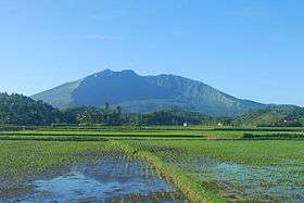
Mount Iriga, also known as Mount Asog, is one of the active volcanoes in the Philippines, in the province of Camarines Sur, in the Philippines.
Mount Iriga is a stratovolcano about a kilometre from Lake Buhi. It rises 1,196 m (3,924 ft) with a base diameter of 10 kilometres (6.2 mi).[1][2]
Iriga erupted in 1628 and 1642.[2] Iriga is generally known for its phreatic explosions.
See also
- List of potentially active volcanoes in the Philippines
- List of inactive volcanoes in the Philippines
- Philippine Institute of Volcanology and Seismology
- Iriga City
References
- 1 2 3 "Iriga". Global Volcanism Program. Smithsonian Institution. Retrieved 2011-09-17.
- 1 2 "Mount Iriga". Philippine Institute of Volcanology and Seismology (PHIVOLCS). Retrieved 2011-09-17.
External links
-
 Media related to Mount Iriga at Wikimedia Commons
This article is issued from Wikipedia - version of the 12/1/2016. The text is available under the Creative Commons Attribution/Share Alike but additional terms may apply for the media files.