Minnan Golden Triangle
| Minnan Golden Triangle 闽南金三角/閩南金三角 | |
|---|---|
|
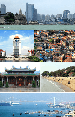
From top: Xiamen's CBD, Xiamen University, colonial houses on Gulangyu Island, South Putuo Temple, beach on Gulangyu Island, and Haicang Bridge | |
 | |
| Coordinates: 25°00′N 118°00′E / 25.0°N 118.0°ECoordinates: 25°00′N 118°00′E / 25.0°N 118.0°E | |
| Country |
|
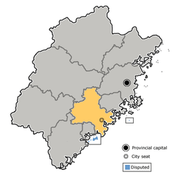
| Province | Fujian |
| Cities | |
| Area | |
| • Total | 25,806.3 km2 (9,963.9 sq mi) |
| Population | |
| • Total | 16,469,863 |
| • Density | 640/km2 (1,700/sq mi) |
| Demonym(s) | Minnan, Banlam, Hoklo |
Minnan Golden Triangle is the region of Southern Fujian, China which includes Xiamen, Quanzhou and Zhangzhou.[1] The region accounts for 40 percent of the GDP of Fujian province.[2] It is the origin of the Minnan or Hoklo people as well as of Southern Min, or the Minnan language.[3]
References
- ↑ http://www.fjfao.gov.cn/english/foreignersinfujian/fujianintheeyesofforeigners/201112/t20111222_625021.htm
- ↑ Multiregional Economic Development in China Rongxing Guo, Hao Gui, Luc Changlei Guo. p 21
- ↑ http://www.fjfao.gov.cn/english/foreignersinfujian/fujianintheeyesofforeigners/201112/t20111222_625021.htm
This article is issued from Wikipedia - version of the 8/30/2016. The text is available under the Creative Commons Attribution/Share Alike but additional terms may apply for the media files.