Mineral Fire
| Mineral Fire | |
|---|---|
|
Smoke rises from the Mineral Fire on Wednesday August 10. | |
| Location | Coalinga, Fresno County, California |
| Coordinates | 36°05′59″N 120°30′38″W / 36.09974°N 120.51057°W |
| Statistics[1] | |
| Date(s) | August 9, 2016 - August 18, 2016 |
| Burned area | 7,050 acres (29 km2) |
| Map | |
 Location in California | |
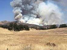
The Mineral Fire was a wildfire that burned in Coalinga, Fresno County, California.[1] The fire burned 7,050 acres (29 km2) of land.
References
- 1 2 "Mineral Fire". CALFIRE. Retrieved 11 August 2016.
This article is issued from Wikipedia - version of the 9/1/2016. The text is available under the Creative Commons Attribution/Share Alike but additional terms may apply for the media files.