Michaelston-super-Ely
For other uses, see Michaelston.
| Michaelston-super-Ely | |
| Welsh: Llanfihangel-ar-Elai | |
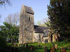 St Michaels Church |
|
 Michaelston-super-Ely |
|
| Principal area | Cardiff |
|---|---|
| Ceremonial county | South Glamorgan |
| Country | Wales |
| Sovereign state | United Kingdom |
| Post town | CARDIFF |
| Dialling code | 029 |
| Police | South Wales |
| Fire | South Wales |
| Ambulance | Welsh |
| EU Parliament | Wales |
| UK Parliament | Cardiff West |
| Welsh Assembly | Cardiff West |
Coordinates: 51°28′34″N 3°16′12″W / 51.476°N 3.270°W
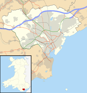
Michaelston-super-Ely is a village, to the west of the city of Cardiff, Wales.
Its Welsh name is Llanfihangel-ar-Elai where llan church + Mihangel Saint Michael + Elai River Ely).
It is approximately half a mile from the boundary with the Vale of Glamorgan. To the north lies the village of St Fagans, and to the east the Ely estate. The community of Michaelston-super-Ely was joined with St Fagans in 1968.[1]
The historic St Michael's Church was decommissioned in 2010. It is a Grade II* listed building dating from the late 12th or early 13th-century.[1]
References
- 1 2 "Church of St Michael, St Fagans". British Listed Buildings. Retrieved 14 February 2016.
External links
- GENUKI(tm) page
- Map sources for Michaelston-super-Ely
This article is issued from Wikipedia - version of the 2/14/2016. The text is available under the Creative Commons Attribution/Share Alike but additional terms may apply for the media files.