Merzalben
| Merzalben | ||
|---|---|---|
| ||
 Merzalben | ||
Location of Merzalben within Südwestpfalz district 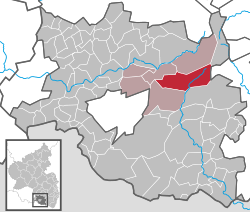 | ||
| Coordinates: 49°14′40″N 7°43′51″E / 49.24446°N 7.73077°ECoordinates: 49°14′40″N 7°43′51″E / 49.24446°N 7.73077°E | ||
| Country | Germany | |
| State | Rhineland-Palatinate | |
| District | Südwestpfalz | |
| Municipal assoc. | Rodalben | |
| Government | ||
| • Mayor | Benno Schwarz (CDU) | |
| Area | ||
| • Total | 30.01 km2 (11.59 sq mi) | |
| Population (2015-12-31)[1] | ||
| • Total | 1,166 | |
| • Density | 39/km2 (100/sq mi) | |
| Time zone | CET/CEST (UTC+1/+2) | |
| Postal codes | 66978 | |
| Dialling codes | 06395 | |
| Vehicle registration | PS | |
| Website | www.merzalben.de | |

Merzalben is a municipality in Südwestpfalz district, in Rhineland-Palatinate, western Germany.
Merzalben's earliest known records date to 1237.
Religion
In 2007 66.3% of the inhabitants were Roman Catholic and 19.3% were Protestant. The rest either belonged to another religion or none.
Politics
The local council in Merzalben consists of 16 councillors, who were elected in the local election on 7 June 2009, and whose honorary local mayor is the chairman.
Culture
The 28-metre-high Luitpold Tower (Luitpoldturm) was established 1909 on the summit of the 610-metre-high Weißenberg hill as observation tower. Gräfenstein Castle is a castle ruin of about two kilometres east of Merzalben. It gave its name to the region.
References
- ↑ "Gemeinden in Deutschland mit Bevölkerung am 31. Dezember 2015" (PDF). Statistisches Bundesamt (in German). 2016.
This article is issued from Wikipedia - version of the 10/23/2016. The text is available under the Creative Commons Attribution/Share Alike but additional terms may apply for the media files.