Merki District
| Merki | ||
|---|---|---|
| District | ||
| Меркі ауданы | ||
| ||
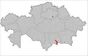 Location of Merki District in Kazakhstan | ||
| Coordinates: KZ 42°52′48″N 73°10′48″E / 42.88000°N 73.18000°E | ||
| Country |
| |
| Region | Jambyl Region | |
| Administrative center | Merki | |
| Area | ||
| • Total | 7,100 km2 (2,700 sq mi) | |
| Population (2013) | ||
| • Total | 81,712 | |
| Time zone | East (UTC+6) | |
Merki (Kazakh: Меркі ауданы) is a district of Jambyl Region in south-eastern Kazakhstan. The administrative center of the district is the selo of Merki.[1]
References
Capital: Taraz | ||
| Districts | 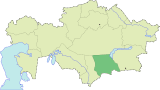 | |
| Major cities | ||
Coordinates: 42°52′48″N 73°10′48″E / 42.88000°N 73.18000°E
This article is issued from Wikipedia - version of the 3/31/2016. The text is available under the Creative Commons Attribution/Share Alike but additional terms may apply for the media files.