Mato Queimado
| Mato Queimado | |
|---|---|
| Municipality | |
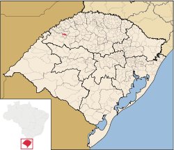 Location in Rio Grande do Sul state | |
 Mato Queimado Location in Brazil | |
| Coordinates: 28°15′21″S 54°36′57″W / 28.25583°S 54.61583°WCoordinates: 28°15′21″S 54°36′57″W / 28.25583°S 54.61583°W | |
| Country |
|
| Region | South Region |
| State | Rio Grande do Sul |
| Mesoregion | Noroeste Rio-Grandense |
| Microregion | Cerro Largo |
| Area | |
| • Total | 114.64 km2 (44.26 sq mi) |
| Population (2015) | |
| • Total | 1,798 |
| • Density | 16/km2 (41/sq mi) |
| Time zone | BRT/BRST (UTC-3/-2) |
| Website |
www |
Mato Queimado is a Brazilian municipality located in the northwestern part of the state of Rio Grande do Sul. The population is 1,798 (2015 est.) in an area of 114.64 km².[1] It is located 489 km west of the state capital of Porto Alegre and northeast of Alegrete.
Neighbouring municipalities
References
External links
- http://www.citybrazil.com.br/rs/matoqueimado/ (Portuguese)
This article is issued from Wikipedia - version of the 5/15/2016. The text is available under the Creative Commons Attribution/Share Alike but additional terms may apply for the media files.