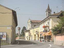
Mairago
| Mairago | ||
|---|---|---|
| Comune | ||
| Comune di Mairago | ||
 | ||
| ||
 | ||
 Mairago Location of Mairago in Italy | ||
| Coordinates: 45°18′N 9°35′E / 45.300°N 9.583°E | ||
| Country | Italy | |
| Region | Lombardy | |
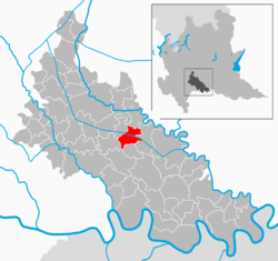
| Province / Metropolitan city | Lodi (LO) | |
| Frazioni | Basiasco | |
| Government | ||
| • Mayor | Davide Tei | |
| Area | ||
| • Total | 11.4 km2 (4.4 sq mi) | |
| Population (1 January 2009[1]) | ||
| • Total | 1,053 | |
| • Density | 92/km2 (240/sq mi) | |
| Demonym(s) | Mairaghini | |
| Time zone | CET (UTC+1) | |
| • Summer (DST) | CEST (UTC+2) | |
| Postal code | 26825 | |
| Dialing code | 0371 | |
| Official website | ||

Mairago is a comune (municipality) in the Province of Lodi in the Italian region Lombardy, located about 40 kilometres (25 mi) southeast of Milan and about 7 kilometres (4 mi) southeast of Lodi.
Mairago borders the following municipalities: Cavenago d'Adda, Turano Lodigiano, Ossago Lodigiano, Secugnago, Brembio.
The main economical activity is the cultivation of corn, barley and, to a lesser extent, wheat. Animal husbandry is also widespread, including beekeeping. Exploitation of methane reservoirs by AGIP is now virtually ended.
References
This article is issued from Wikipedia - version of the 10/31/2016. The text is available under the Creative Commons Attribution/Share Alike but additional terms may apply for the media files.