Mablethorpe railway station
| Mablethorpe | |
|---|---|
 | |
| Location | |
| Place | Mablethorpe |
| Area | Lincolnshire |
| Coordinates | 53°20′28″N 0°15′30″E / 53.3410°N 0.2583°ECoordinates: 53°20′28″N 0°15′30″E / 53.3410°N 0.2583°E |
| Grid reference | TF504850 |
| Operations | |
| Original company | Louth and East Coast Railway |
| Pre-grouping | Great Northern Railway |
| Post-grouping | LNER |
| Platforms | 4 |
| History | |
| 17 October 1877 | opened |
| 5 October 1970[1] | closed |
| Disused railway stations in the United Kingdom | |
|
Closed railway stations in Britain A B C D–F G H–J K–L M–O P–R S T–V W–Z | |
|
| |
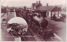
Mablethorpe railway station was a station in the town of Mablethorpe, Lincolnshire which is now closed.[2] The station was demolished soon after closure. Since 1985 only a short section of platform survives forming a wall of a flower bed in a public garden.
The station was situated on the north side of High Street, between the present-day Station Road and Alexandra Road.
| Preceding station | Disused railways | Following station | ||
|---|---|---|---|---|
| Sutton-on-Sea | Great Northern Railway Mablethorpe Loop |
Theddlethorpe | ||
References
- ↑ "E. Lincs Railway - final weeks". Retrieved 10 July 2008.
- ↑ British Railways Atlas.1947. p.17
This article is issued from Wikipedia - version of the 3/1/2016. The text is available under the Creative Commons Attribution/Share Alike but additional terms may apply for the media files.