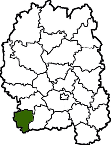
Liubar Raion
| Liubar Raion Любарський район | |||
|---|---|---|---|
| Raion | |||
| |||
 | |||
| Coordinates: 49°55′20″N 27°45′19″E / 49.92222°N 27.75528°ECoordinates: 49°55′20″N 27°45′19″E / 49.92222°N 27.75528°E | |||
| Country |
| ||
| Region | Zhytomyr Oblast | ||
| Admin. center | Liubar | ||
| Subdivisions |
List
| ||
| Area | |||
| • Total | 757 km2 (292 sq mi) | ||
| Population (2013) | |||
| • Total |
| ||
| Time zone | EET (UTC+2) | ||
| • Summer (DST) | EEST (UTC+3) | ||
| Area code | +380 | ||
Liubar Raion (Ukrainian: Любарський район) is a raion (district) of Zhytomyr Oblast, northern Ukraine. Its administrative centre is located at the urban-type settlement of Liubar. The raion covers an area of 757 square kilometres (292 sq mi). Population: 27,700 (2013 est.)[1]
References
- ↑ "Чисельність наявного населення України (Actual population of Ukraine)" (in Ukrainian). State Statistics Service of Ukraine. Retrieved 21 January 2015.
| Raions | |||||||
|---|---|---|---|---|---|---|---|
| Cities |
| ||||||
| |||||||
This article is issued from Wikipedia - version of the 1/23/2015. The text is available under the Creative Commons Attribution/Share Alike but additional terms may apply for the media files.