Lika (river)
| Lika | |
|---|---|
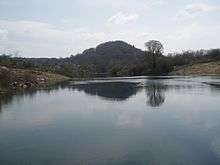 Lika River, near Kosinj | |
| Country | Croatia |
| Basin | |
| Main source |
Velebit Mountains 600 m (2,000 ft) |
| River mouth |
ponor 480 m (1,570 ft) |
| Basin size | 1,014 km2 (392 sq mi) |
| Physical characteristics | |
| Length | 77 km (48 mi) |
| Discharge |
|
The Lika is a river in Croatia which gives its name to the Lika region. It is 77 kilometres (48 mi) long and it has a basin with an area of 1,014 square kilometres (392 sq mi). Its average discharge at the measurement station in Bilaj (covering 225 km2 of the basin) is 7.33 m3/s, and it can go completely dry.[1]
It is known as a sinking river because at the end of its course, it flows into a series of ponors or swallow-holes and disappears from the surface. The Lika River rises near the village of Kukljić at the foot of the Velebit Mountains, flows in a northwesterly direction past the town of Gospić, enters and leaves Lake Krušćica, and continues to the northwest until it sinks into the karst topography at ponors near Lipovo Polje.
References
- ↑ "Karakteristike značajnijih vodotoka". Vodnogospodarska osnova Hrvatske - Strategija upravljanja vodama (in Croatian). Croatian Parliament. Retrieved 2011-12-18.
Coordinates: 44°46′N 15°10′E / 44.767°N 15.167°E