Land, Norway
| Land | |
|---|---|
| District | |
|
| |
| Country | Norway |
| County | Oppland |
| Region | Austlandet |
| Adm. Center | Dokka |
| Area | |
| • Total | 1,683 km2 (650 sq mi) |
| Population (2005) | |
| • Total | 12,855 |
| • Density | 7.6/km2 (20/sq mi) |
| Demonym(s) | Landing |
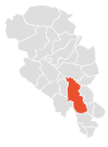
Map of Land, Oppland.
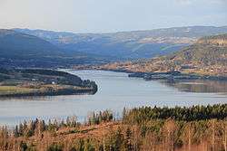
Land is a traditional district in Oppland, Norway consisting of the municipalities Nordre Land and Søndre Land. In the early Viking Age, before Harald Fairhair, Land was a petty kingdom. Land is centered on the northern part of Randsfjorden. The parish of Land was a formannskapsdistrikt from 1837, and split into Nordre and Søndre Land in 1847. By the time of partition Land had a population of 9,199.[1]
References
- ↑ "Land – landskap i Oppland". snl.no.
Coordinates: 60°14′N 9°52′E / 60.233°N 9.867°E
This article is issued from Wikipedia - version of the 10/5/2016. The text is available under the Creative Commons Attribution/Share Alike but additional terms may apply for the media files.