Kraftsdorf
| Kraftsdorf | ||
|---|---|---|
| ||
 Kraftsdorf | ||
Location of Kraftsdorf within Greiz district 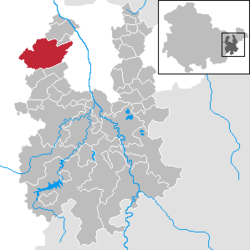 | ||
| Coordinates: 50°52′33″N 11°54′50″E / 50.87583°N 11.91389°ECoordinates: 50°52′33″N 11°54′50″E / 50.87583°N 11.91389°E | ||
| Country | Germany | |
| State | Thuringia | |
| District | Greiz | |
| Government | ||
| • Mayor | Bernhard Bräuner | |
| Area | ||
| • Total | 41.21 km2 (15.91 sq mi) | |
| Population (2015-12-31)[1] | ||
| • Total | 3,803 | |
| • Density | 92/km2 (240/sq mi) | |
| Time zone | CET/CEST (UTC+1/+2) | |
| Postal codes | 07586 | |
| Dialling codes | 036606 | |
| Vehicle registration | GRZ | |
| Website | www.kraftsdorf.de | |

Kraftsdorf is a municipality in the district of Greiz, in Thuringia, Germany. It is dispersed in different municipal units with their sub-set of hamlets:
- Kraftsdorf
- Harpersdorf
- Kraftsdorf
- Oberndorf
- Niederndorf
- Kaltenborn
- Niederndorf
- Rüdersdorf
- Grüna
- Rüdersdorf (with Stübnitz)
- Töppeln
- Mühlsdorf
- Pörsdorf
- Töppeln
See also
 Media related to Kraftsdorf at Wikimedia Commons
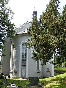
Church in Kraftsdorf
References
This article is issued from Wikipedia - version of the 10/1/2016. The text is available under the Creative Commons Attribution/Share Alike but additional terms may apply for the media files.