Kerken
| Kerken | ||
|---|---|---|
| ||
 Kerken | ||
Location of Kerken within Kleve district 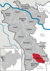
 | ||
| Coordinates: 51°27′26″N 6°22′26″E / 51.45722°N 6.37389°ECoordinates: 51°27′26″N 6°22′26″E / 51.45722°N 6.37389°E | ||
| Country | Germany | |
| State | North Rhine-Westphalia | |
| Admin. region | Düsseldorf | |
| District | Kleve | |
| Area | ||
| • Total | 58 km2 (22 sq mi) | |
| Population (2015-12-31)[1] | ||
| • Total | 13,262 | |
| • Density | 230/km2 (590/sq mi) | |
| Time zone | CET/CEST (UTC+1/+2) | |
| Postal codes | 47647 | |
| Dialling codes | 0 28 33 | |
| Vehicle registration | KLE | |
| Website | www.kerken.de | |

Kerken with the towns of Aldekerk, Eyll, Nieukerk and Stenden, is a municipality in the district of Kleve in the state of North Rhine-Westphalia, Germany. It is located near the border with the Netherlands, approx. 15 km north-east of Venlo.
Towns and municipalities in Kleve (district) | ||
|---|---|---|
References
- ↑ "Amtliche Bevölkerungszahlen". Landesbetrieb Information und Technik NRW (in German). 18 July 2016.
This article is issued from Wikipedia - version of the 5/20/2015. The text is available under the Creative Commons Attribution/Share Alike but additional terms may apply for the media files.