Kaišiadorys District Municipality
| Kaišiadorys District Municipality Kaišiadorių rajono savivaldybė | ||
|---|---|---|
| Municipality | ||
|
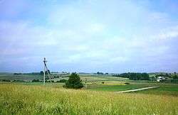
Dzūkai elevation near Viliūnai | ||
| ||
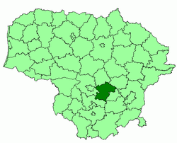 Location of Kaišiadorys district municipality within Lithuania | ||
| Country |
| |
| Ethnographic region | Aukštaitija | |
| County |
| |
| Capital | Kaišiadorys | |
| Elderships | 11 | |
| Area | ||
| • Total | 1,087 km2 (420 sq mi) | |
| Area rank | 36th | |
| Population (2001 census) | ||
| • Total | 37,600 | |
| • Rank | 31st | |
| • Density | 35/km2 (90/sq mi) | |
| • Density rank | 25th | |
| Time zone | EET (UTC+2) | |
| • Summer (DST) | EEST (UTC+3) | |
| Telephone code | 346 | |
| Major settlements |
| |
| Website |
www | |

Kaišiadorys District Municipality is one of 60 municipalities in Lithuania.
External links
- Žasliai Web Page Žasliai is in Kaišiadorys District
Coordinates: 54°47′35″N 24°25′34″E / 54.79306°N 24.42611°E
This article is issued from Wikipedia - version of the 5/14/2016. The text is available under the Creative Commons Attribution/Share Alike but additional terms may apply for the media files.