Isfara District
| Isfara District Ноҳияи Исфара | |
|---|---|
| District | |
| Ноҳияи Исфара | |
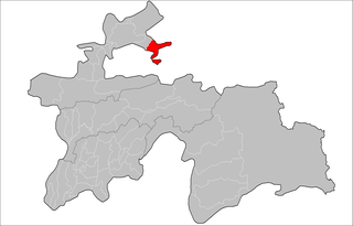 Location of Isfara District in Tajikistan | |
| Country |
|
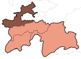
| Province | Sughd |
| Capital | Isfara |
| Time zone | TJT (UTC+5) |
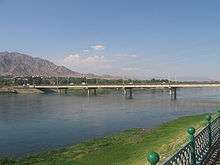
Isfara District or Nohiya-i Isfara (Tajik: Ноҳияи Исфара; Persian: ناحیۀ اسفره) is a district at the northeastern edge of Sughd province, Tajikistan, bordering on Uzbekistan's Ferghana Valley to the north and Kyrgyzstan to the south.[1] Its capital is Isfara. Vorukh, an enclave in Kyrgyzstan, is also part of Isfara.
Administrative divisions
The district is divided administratively into jamoats. They are as follows (and population).[2]
| Jamoats of Isfara District | |||||||||||
| Jamoat | Population | ||||||||||
|---|---|---|---|---|---|---|---|---|---|---|---|
| Navgilem | 28311 | ||||||||||
| Khonabad | 9614 | ||||||||||
| Kulkent | 17732 | ||||||||||
| Shahrak | 13991 | ||||||||||
| Chilgazi | 12150 | ||||||||||
| Lakkon | 5514 | ||||||||||
| Surkh | 10396 | ||||||||||
| Chorku | 28846 | ||||||||||
| Vorukh | 23121 | ||||||||||
References
- ↑ Republic of Tajikistan, map showing administrative division as of January 1, 2004, "Tojjikoinot" Cartographic Press, Dushanbe
- ↑ "List of Jamoats". UN Coordination, Tajikistan. Retrieved April 4, 2009.
External links
- Habib Borjian, "Esfara", in Encyclopaedia Iranica, Columbia University (enter keyword "Esfara" in search field to access the article).
Coordinates: 40°07′N 70°38′E / 40.117°N 70.633°E
This article is issued from Wikipedia - version of the 12/2/2016. The text is available under the Creative Commons Attribution/Share Alike but additional terms may apply for the media files.