Imboden District
| Imboden District Bezirk Imboden District Il Plaun | |
|---|---|
| District | |
 | |
| Coordinates: 46°51′N 9°21′E / 46.85°N 9.35°ECoordinates: 46°51′N 9°21′E / 46.85°N 9.35°E | |
| Country |
|
| Canton |
|
| Capital | Domat/Ems |
| Area | |
| • Total | 203.81 km2 (78.69 sq mi) |
| Population (2015) | |
| • Total | 20,158 |
| • Density | 99/km2 (260/sq mi) |
| Time zone | CET (UTC+1) |
| • Summer (DST) | CEST (UTC+2) |
| Municipalities | 7 |
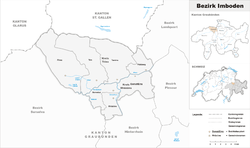
Imboden District (German: 'Bezirk Imboden', Romansh: ![]() District dal Plaun ) is an administrative district in the canton of Graubünden, Switzerland. It has an area of 203.78 km2 (78.68 sq mi) and has a population of 20,158 (as of 31 December 2015).[1]
District dal Plaun ) is an administrative district in the canton of Graubünden, Switzerland. It has an area of 203.78 km2 (78.68 sq mi) and has a population of 20,158 (as of 31 December 2015).[1]
It consists of two Kreise (sub-districts) and seven municipalities:
| Rhäzüns sub-district | ||||
|---|---|---|---|---|
| Municipality | Population (31 December 2015)[1] |
Area (km²) | ||
| Bonaduz | 3,183 | 14.45 | ||
| Domat/Ems | 7,880 | 24.24 | ||
| Rhäzüns | 1,425 | 13.28 | ||
| Trins sub-district | ||||
|---|---|---|---|---|
| Municipality | Population (31 December 2015)[1] |
Area (km²) | ||
| Felsberg | 2,476 | 13.39 | ||
| Flims | 2,697 | 50.46 | ||
| Tamins | 1,174 | 40.71 | ||
| Trin | 1,323 | 47.25 | ||
Languages
| Languages of Imboden District, GR | ||||||
| Languages | Census 2000 | |||||
| Number | Percent | |||||
| German | 13,498 | 80.1% | ||||
| Romansh | 1,447 | 8.6% | ||||
| Italian | 709 | 4.2% | ||||
| TOTAL | 16,859 | 100% | ||||
References
- 1 2 3 Swiss Federal Statistical Office - STAT-TAB, online database – Ständige und nichtständige Wohnbevölkerung nach institutionellen Gliederungen, Geburtsort und Staatsangehörigkeit (German) accessed 30 August 2016
This article is issued from Wikipedia - version of the 1/29/2016. The text is available under the Creative Commons Attribution/Share Alike but additional terms may apply for the media files.