Hajigabul District
| Hacıqabul | |
|---|---|
| Rayon | |
.svg.png) Map of Azerbaijan showing Hajigabul rayon | |
| Country | Azerbaijan |
| Capital | Qazimemmed |
| Area | |
| • Total | 1,640 km2 (630 sq mi) |
| Postal code | 2400 |
| Telephone code | (+994) 21[1] |
Hajigabul (Hacıqabul) is a rayon of Azerbaijan.
There are 31 populated areas. One of them is a city, 1 city-like settlement, 4 settlements and 25 villages.
There are 15 administrative-territorial units, 5 medical institutions and 55 cultural centers.
The Pirsaat River and valley is located in this rayon.
Gallery
- Hacigabul
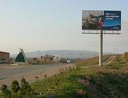 Road from Shirvan reaching Hajigabul Rayon. Hacıqabul city (or Qazıməmməd) in the background
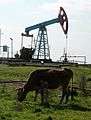 Onshore oil in the vicinity of Hacigabul
References
- ↑ "Şəhərlərarası telefon kodları". Aztelekom MMC. Aztelekom İB. Retrieved 19 August 2015. (Azerbaijani)
| Part of the series on |
| Azerbaijan Azərbaycan |
|---|
  |
| Culture |
| History |
| Demographics |
| Geography |
| Administrative divisions |
| Azerbaijan portal |
Coordinates: 40°02′17″N 48°56′13″E / 40.037999°N 48.937038°E
This article is issued from Wikipedia - version of the 8/21/2015. The text is available under the Creative Commons Attribution/Share Alike but additional terms may apply for the media files.