Giheung-gu
| Giheung-gu 기흥구 | |
|---|---|
| Non-autonomous District | |
| Korean transcription(s) | |
| • Hanja | 器興區 |
| • Revised Romanization | Giheung-gu |
| • McCune-Reischauer | Kihŭng-gu |
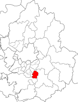 Map of Gyeonggi highlighting Giheung-gu. | |
| Country | South Korea |
| Region | Sudogwon (Gijeon) |
| Province | Gyeonggi |
| City | Yongin |
| Area | |
| • Total | 81.7 km2 (31.5 sq mi) |
| Population (2009) | |
| • Total | 321,015 |
| • Dialect | Seoul |
| Website | Giheung-gu Office |
Giheung-gu is a gu (district) in Yongin, South Korea. It has 10 dong (neighborhoods). Its area is 81.7 km² and it has 321,015 inhabitants (in 2009). Giheung-gu was formed in 2005. It was formed with other gu in Yongin in 2005.
Administrative divisions
Giheung-gu is divided into the following "dong"s.
- Giheung-dong (divided in turn into Gomae-dong and Gongse-dong)
- Sanggal-dong (divided in turn into Sanggal-dong, Bora-dong and Jigok-dong)
- Singal-dong (divided in turn into Singal-dong, Hagal-dong and Yeongdeok-dong)
- Guseong-dong (divided in turn into Eonnam-dong and Cheongdeok-dong)
- Dongbaek-dong (divided in turn into Dongbaek-dong and Jung-dong)
- Seonong-dong (combination of Seocheon-dong and Nongseo-dong)
- Gugal-dong
- Mabuk-dong
- Bojeong-dong
- Sangha-dong
List of Gu in Yongin
Gallery
-
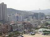
Gugal-dong
References
Suwon (capital) | ||||||||||||||||||||||||||||||||||||
 | Specific cities |
| ||||||||||||||||||||||||||||||||||
| Cities | ||||||||||||||||||||||||||||||||||||
| Counties | ||||||||||||||||||||||||||||||||||||
Coordinates: 37°16′49″N 127°06′53″E / 37.280406°N 127.114659°E
This article is issued from Wikipedia - version of the 5/29/2014. The text is available under the Creative Commons Attribution/Share Alike but additional terms may apply for the media files.