Georgia State Route 113
| ||||
|---|---|---|---|---|
 | ||||
| Route information | ||||
| Maintained by GDOT | ||||
| Length: | 58.10 mi[1] (93.50 km) | |||
| Major junctions | ||||
| South end: |
| |||
|
| ||||
| North end: |
| |||
| Location | ||||
| Counties: | Carroll, Haralson, Paulding, Polk, Bartow | |||
| Highway system | ||||
| ||||

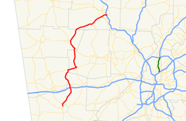
State Route 113 (SR 113) is a state highway in western Georgia. It is a 58.1-mile-long (93.5 km) route, connecting U.S. Route 27 (US 27) in Carrollton and Interstate 75 (I-75) east of Cartersville.
Route description
SR 113 begins at U.S. 27/SR 1 in Carrollton. The route runs north, intersects Interstate 20, then passes through the town of Temple. In extreme eastern Haralson County, the route begins a concurrency with SR 120 running east, then overlaps SR 101 northward. North of Yorkville, SR 101/SR 113 also overlap U.S. 278/SR 6 to Rockmart. The route departs Rockmart to the northeast. After crossing the Etowah River, the route passes through downtown Cartersville as Main Street, before reaching its northern terminus at Interstate 75 east of Cartersville. SR 113 is usually marked as a north-south signed highway, but in areas like Taylorsville, the highway is signed as an east-west route. It is also signed as a west routed highway at its northern terminus at Interstate 75.
Major intersections
| County | Location | mi[1] | km | Destinations | Notes |
|---|---|---|---|---|---|
| Carroll | Carrollton | 0 | 0.0 | Southern terminus | |
| 1.1 | 1.8 | ||||
| Temple | 9.3 | 15.0 | |||
| 10.3 | 16.6 | ||||
| 10.9 | 17.5 | begin overlap with State Route 274 | |||
| 11.1 | 17.9 | end overlap with State Route 274 | |||
| Haralson | Draketown | 18.4 | 29.6 | begin overlap with State Route 120 | |
| Paulding | Union | 22.2 | 35.7 | end overlap with Stare Route 120, begin overlap with State Route 101 | |
| Polk | | 31.6 | 50.9 | begin overlap with U.S. Route 278 | |
| Rockmart | 32.5 | 52.3 | end overlaps with U.S. Route 278 and State Route 101 | ||
| Bartow | | 51.4 | 82.7 | begin overlap with State Route 61 | |
| Cartersville | 55.4 | 89.2 | begin overlap with State Route 293 | ||
| 55.8 | 89.8 | end overlaps with State Routes 61 and 293 | |||
| 56.7 | 91.2 | ||||
| 58.1 | 93.5 | Northern terminus | |||
1.000 mi = 1.609 km; 1.000 km = 0.621 mi
| |||||
See also
-
.svg.png) Georgia (U.S. state) portal
Georgia (U.S. state) portal -
 U.S. Roads portal
References
- 1 2 Google (31 October 2012). "GA-113" (Map). Google Maps. Google. Retrieved 31 October 2012.
External links
-
 Media related to Georgia State Route 113 at Wikimedia Commons