General Carneiro
For the city in Mato Grosso, see General Carneiro, Mato Grosso.
| General Carneiro | |
|---|---|
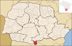 Location of General Carneiro | |
| Coordinates: 26°25′40″S 51°18′57″W / 26.42778°S 51.31583°WCoordinates: 26°25′40″S 51°18′57″W / 26.42778°S 51.31583°W | |
| Country |
|
| Region | South |
| State | Paraná |
| Founded | November 19 |
| Government | |
| • Mayor | Ivanor Dacheri (PSB) |
| Area | |
| • Total | 1,070.252 km2 (413.227 sq mi) |
| Elevation | 983 m (3,225 ft) |
| Population (2012) | |
| • Total | 13,635 |
| • Density | 13/km2 (33/sq mi) |
| [1] | |
| Time zone | UTC-3 (UTC-3) |
| • Summer (DST) | UTC-2 (UTC-2) |
| HDI (2000) | 0.711 – medium[2] |
| Website | www.generalcarneiro.pr.gov.br |
General Carneiro is the southernmost city in the Brazilian state of Paraná.
References
- ↑ "2012 Populational Estimate" (PDF). Censo Populacional 2012. Instituto Brasileiro de Geografia e Estatística (IBGE). July 2012. Retrieved September 8, 2012.
- ↑ - UNDP
| Wikimedia Commons has media related to General Carneiro. |
This article is issued from Wikipedia - version of the 5/15/2016. The text is available under the Creative Commons Attribution/Share Alike but additional terms may apply for the media files.