Frutigen District
| Frutigen District Amtsbezirk Frutigen | |
|---|---|
| District | |
 | |
| Country |
|
| Canton |
|
| Capital | Frutigen |
| Area | |
| • Total | 489 km2 (189 sq mi) |
| Population (2007) | |
| • Total | 18,581 |
| • Density | 38/km2 (98/sq mi) |
| Time zone | CET (UTC+1) |
| • Summer (DST) | CEST (UTC+2) |
| Municipalities | 7 |
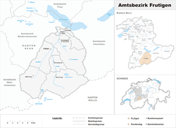
Frutigen District was a district in the canton of Bern in Switzerland with its seat at Frutigen. It included seven municipalities in an area of 490 km²:
| Municipality | Population (01.01.2005) | Area (km²) |
|---|---|---|
| Adelboden | 3,686 | 88.2 |
| Aeschi bei Spiez | 1,967 | 30.9 |
| Frutigen | 6,648 | 71.8 |
| Kandergrund | 1,092 | 32.0 |
| Kandersteg | 1,193 | 134.5 |
| Krattigen | 916 | 6.0 |
| Reichenbach im Kandertal | 3,342 | 125.8 |
References
This article is based on a translation of an article from the German Wikipedia.
External links
- Frutigen (Herrschaft, Amtsbezirk) in German, French and Italian in the online Historical Dictionary of Switzerland.
- Adelboden
- Aeschi b/Spiez
- Frutigen
- Kandergrund
- Kandersteg
- Krattigen
- Reichenbach i/Kandertal
Coordinates: 46°35′00″N 7°39′00″E / 46.5833°N 7.65°E
This article is issued from Wikipedia - version of the 3/15/2013. The text is available under the Creative Commons Attribution/Share Alike but additional terms may apply for the media files.