Freihausen
| Freihausen | |
|---|---|
| municipality of Seubersdorf in der Oberpfalz | |
 | |
 Freihausen | |
| Coordinates: 49°8′47″N 11°33′34″E / 49.14639°N 11.55944°ECoordinates: 49°8′47″N 11°33′34″E / 49.14639°N 11.55944°E | |
| Country | Germany |
| State | Bavaria |
| Admin. region | Upper Palatinate |
| District | Landkreis Neumarkt in der Oberpfalz |
| Municipality | Seubersdorf in der Oberpfalz |
| First mentioned | 1326 [1] |
| Population | |
| • Total | 230 |
| Time zone | CET/CEST (UTC+1/+2) |
| Postal codes | 92358 |
| Dialling codes | 09497 |
| Vehicle registration | NM |
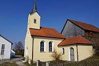
Freihausen - Chapel
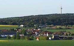
Freihausen is a small village in the municipality of Seubersdorf in the German state of Bavaria. It is in the Upper Palatinate, in the Neumarkt district. It has a total population of 230 people. [1]
Geography
The village lies about 13 kilometers south-east from Neumarkt, on the Franconian Jura. The Wissinger Laber arises south-east from Freihausen.
Climate
The climate in Freihausen is categorized in the Köppen climate classification as Dfb (humid continental). The average temperature of 7.7 °C is slightly below the German average (7.8 °C), the average precipitation of 735 mm per year above the German average (approximately 700 mm). [2]
Weblinks
References
- 1 2 Freihausen, Gemeinde Seubersdorf. Website municipality Seubersdorf i.d.OPf. April 2nd, 2015.
- ↑ climate-data.org - Freihausen, DEU. Website climate-data.org. April 2nd, 2015.
This article is issued from Wikipedia - version of the 3/25/2016. The text is available under the Creative Commons Attribution/Share Alike but additional terms may apply for the media files.