Dolga Poljana
| Dolga Poljana | |
|---|---|
 Dolga Poljana Location in Slovenia | |
| Coordinates: 45°52′33.34″N 13°56′9.37″E / 45.8759278°N 13.9359361°ECoordinates: 45°52′33.34″N 13°56′9.37″E / 45.8759278°N 13.9359361°E | |
| Country |
|
| Traditional region | Littoral |
| Statistical region | Gorizia |
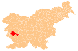
| Municipality | Ajdovščina |
| Area | |
| • Total | 2.31 km2 (0.89 sq mi) |
| Elevation | 155.8 m (511.2 ft) |
| Population (2002) | |
| • Total | 303 |
| [1] | |
Dolga Poljana (pronounced [ˈdoːu̯ɡa pɔˈljaːna]) is a village in the Vipava Valley east of Ajdovščina in the Littoral region of Slovenia.[2]
Stone arch bridge
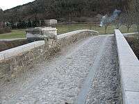
The stone arch linking Dolga Poljana over the Vipava River to Dolenje
A stone arch bridge over the Vipava River links Dolga Poljana to the village of Dolenje. The three-arch bridge was built in the 19th century. It is paved with gravel and is supported by buttresses that are reinforced with groynes on the upstream side. There is a low stone wall on both sides of the bridge, and a shrine with a semi-circular niche once stood at it.[3]
References
- ↑ Statistical Office of the Republic of Slovenia
- ↑ Ajdovščina municipal site
- ↑ "9530: Dolenje pri Ajdovščini - Kamniti most čez reko Vipavo" [9530: Dolenje at Ajdovščina – The Stone Bridge Across the Vipava River]. Register nepremične kulturne dediščine [Registry of Immovable Cultural Heritage] (in Slovenian). Ministry of Culture, Republic of Slovenia. Retrieved 12 April 2014.
External links
| Settlements | Administrative centre: Ajdovščina
|  | ||||||
|---|---|---|---|---|---|---|---|---|
| Landmarks |
| |||||||
| Notable people |
| |||||||
This article is issued from Wikipedia - version of the 12/4/2014. The text is available under the Creative Commons Attribution/Share Alike but additional terms may apply for the media files.