Cueva de Ágreda
| Cueva de Ágreda, Spain | |
|---|---|
_Mapa.svg.png) Location of Cueva de Ágreda in Soria Province | |
| Country | Spain |
| Autonomous community | Castile and León |
| Province | Soria |
| Municipality | Cueva de Ágreda |
| Area | |
| • Total | 29 km2 (11 sq mi) |
| Population (2004) | |
| • Total | 95 |
| • Density | 3.3/km2 (9/sq mi) |
| Time zone | CET (UTC+1) |
| • Summer (DST) | CEST (UTC+2) |
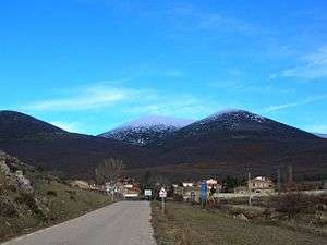
View of Cueva de Ágreda town with the massive summits of the Moncayo Massif in the background
Cueva de Ágreda is a municipality located in the province of Soria, Castile and León, Spain. According to the 2004 census (INE), the municipality has a population of 95 inhabitants.
The nearest main town is Ólvega.
External links
| Wikimedia Commons has media related to Cueva de Ágreda. |
Coordinates: 41°46′N 1°53′W / 41.767°N 1.883°W
This article is issued from Wikipedia - version of the 1/25/2016. The text is available under the Creative Commons Attribution/Share Alike but additional terms may apply for the media files.