Coxim
| Coxim | ||
|---|---|---|
| Municipality | ||
 | ||
| ||
 Coxim | ||
| Coordinates: 18°30′25″S 54°45′36″W / 18.50694°S 54.76000°W | ||
| Country |
| |
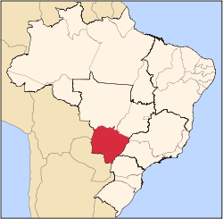
| State | Mato Grosso do Sul | |
| Region | Center-West | |
| Government | ||
| • Mayor | Aluizio São José | |
| Area | ||
| • Total | 6,411.552 km2 (2,475.514 sq mi) | |
| Elevation | 238 m (781 ft) | |
| Population (2007) | ||
| • Total | 31,797 | |
| • Density | 5.0/km2 (13/sq mi) | |
| Demonym(s) | Coxinenses | |
| Time zone | UTC-4 (UTC-4) | |
| • Summer (DST) | UTC-3 (UTC-3) | |
| Postal Code | 79400-000 | |
| Area code(s) | +55 67 | |
| Website | Official website | |

Coxim is a municipality located in the Brazilian state of Mato Grosso do Sul. Its population was 33,021 (2005) and its area is 6,412 km².[1] It was founded in 1729.
It is located at the confluence of the Coxim and Taquari rivers. Its economy is based on tourism, fishing and animal husbandry.
References
- ↑ IBGE - "Archived copy". Archived from the original on January 9, 2007. Retrieved August 3, 2014.
External links
Capital: Campo Grande | |||||||||||||||
| Mesoregion Centro Norte de Mato Grosso do Sul |
|  | |||||||||||||
| Mesoregion Leste de Mato Grosso do Sul |
| ||||||||||||||
| Mesoregion Pantanal Sul Mato-Grossense |
| ||||||||||||||
| Mesoregion Sudoeste de Mato Grosso do Sul |
| ||||||||||||||
This article is issued from Wikipedia - version of the 11/6/2016. The text is available under the Creative Commons Attribution/Share Alike but additional terms may apply for the media files.