Convenience Township, Pope County, Arkansas
| Convenience Township | |
|---|---|
| Township | |
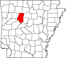
 Convenience Township Location in Arkansas | |
| Coordinates: 35°20′00″N 92°56′41″W / 35.33333°N 92.94472°WCoordinates: 35°20′00″N 92°56′41″W / 35.33333°N 92.94472°W | |
| Country |
|
| State |
|
| County | Pope |
| Area | |
| • Total | 18.6 sq mi (48 km2) |
| • Land | 18.5 sq mi (48 km2) |
| • Water | 0.1 sq mi (0.3 km2) |
| Elevation | 682 ft (208 m) |
| Population (2000) | |
| • Total | 933 |
| • Density | 50/sq mi (20/km2) |
| Time zone | CST (UTC-6) |
| • Summer (DST) | CDT (UTC-5) |
| Area code(s) | 870 |
| GNIS feature ID | 69701 |
Convenience Township is one of nineteen current townships in Pope County, Arkansas, USA.[1] As of the 2000 census, its unincorporated population was 933.
Geography
According to the United States Census Bureau, Convenience Township covers an area of 18.6 square miles (48 km2); 18.5 square miles (48 km2) of land and 0.1 square miles (0.26 km2) of water.
References
- United States Census Bureau 2008 TIGER/Line Shapefiles
- United States Board on Geographic Names (GNIS)
- United States National Atlas
- ↑ "Convenience Township, Pope County, Arkansas." U.S. Census Bureau. Breakdown. Retrieved June 20, 2010.
External links
This article is issued from Wikipedia - version of the 11/30/2016. The text is available under the Creative Commons Attribution/Share Alike but additional terms may apply for the media files.