Cholargos
| Cholargos Χολαργός | |
|---|---|
 Cholargos | |
|
Location within Athens  | |
| Coordinates: 38°0′N 23°48′E / 38.000°N 23.800°ECoordinates: 38°0′N 23°48′E / 38.000°N 23.800°E | |
| Country | Greece |
| Administrative region | Attica |
| Regional unit | North Athens |
| Municipality | Papagou-Cholargos |
| Districts | 1 |
| • Municipal unit | 3.950 km2 (1.525 sq mi) |
| Elevation | 202 m (663 ft) |
| Population (2011)[1] | |
| • Municipal unit | 30,840 |
| • Municipal unit density | 7,800/km2 (20,000/sq mi) |
| Time zone | EET (UTC+2) |
| • Summer (DST) | EEST (UTC+3) |
| Postal code | 155 61, 155 62 |
| Area code(s) | 210 65 |
| Vehicle registration | I, Y, Z |
Cholargos (Greek: Χολαργός) is an affluent suburb of Athens, Greece, located northeast of the city center and about 6 kilometers (3.7 miles) away from Syntagma Square. Since the 2011 local government reform it is part of the municipality Papagou-Cholargos, of which it is the seat and a municipal unit.[2] The municipal unit has an area of 3.950 km2.[3] The main thoroughfare is Mesogeion Avenue, which connects Cholargos with central Athens and the northern beltway Motorway 6.
Cholargos was the name of a deme of ancient Attica. The most prominent citizen of ancient Cholargos was Pericles. Cholargos was part of the community of Chalandri until 1933, when it became a separate community. It became a municipality in 1963.[4]
International relations
Cholargos is twinned with:
Historical population
| Year | Population |
|---|---|
| 1981 | 31,703 |
| 1991 | 33,691 |
| 2001 | 32,166 |
| 2011 | 30,840 |
Government and infrastructure
The headquarters of the Ministry of Infrastructure, Transport and Networks are in Cholargos.[5]
Gallery
-
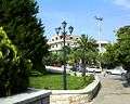
City's aesthetic
-

Cholargos municipal park
-

Agia Triada Church
-
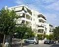
Urban neighbourhood
See also
External links
- Official website (Greek)
References
- ↑ "Απογραφή Πληθυσμού - Κατοικιών 2011. ΜΟΝΙΜΟΣ Πληθυσμός" (in Greek). Hellenic Statistical Authority.
- ↑ Kallikratis law Greece Ministry of Interior (Greek)
- ↑ "Population & housing census 2001 (incl. area and average elevation)" (PDF) (in Greek). National Statistical Service of Greece. Archived from the original (PDF) on 2015-09-21.
- ↑ EETAA local government changes
- ↑ "Contact." Ministry of Infrastructure, Transport and Networks. Retrieved on 16 January 2013. "Addr 2, Anastaseos Str and Tsigante, Postal Code 101 91, Cholargos (next to metro station "Ethniki Amina")" - Address in Greek: "Διεύθυνση Αναστάσεως 2 και Τσιγάντε, Τ.Κ 101 91, Παπάγου (δίπλα στη στάση του μετρό "Εθνική Άμυνα")"
 |
Neo Psychiko | Chalandri | Agia Paraskevi | |
| Athens | |
Agia Paraskevi | ||
| ||||
| | ||||
| Papagou | Papagou | Zografou |