Chilcombe
| Chilcombe | |
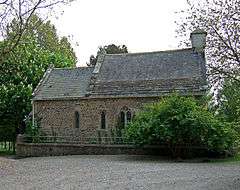 Chilcombe church |
|
 Chilcombe |
|
| Population | 10 [1] |
|---|---|
| OS grid reference | SY528910 |
| Civil parish | Chilcombe |
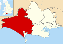
| District | West Dorset |
| Shire county | Dorset |
| Region | South West |
| Country | England |
| Sovereign state | United Kingdom |
| Post town | Bridport |
| Postcode district | DT6 |
| Police | Dorset |
| Fire | Dorset and Wiltshire |
| Ambulance | South Western |
| EU Parliament | South West England |
| UK Parliament | West Dorset |
Coordinates: 50°43′02″N 2°40′10″W / 50.7173°N 2.6695°W
Chilcombe is a hamlet and civil parish in Dorset, England, situated in the West Dorset administrative district about 4 miles (6.4 km) east of Bridport and 10 miles (16 km) west of the county town, Dorchester. It comprises a church, an 18th-century farmhouse with farm buildings, and a couple of cottages.[2] In 2013 the estimated population of the parish was 10.[1]
In 1086 in the Domesday Book Chilcombe was recorded as Ciltecome;[3] it had 14 households, 3 ploughlands, 25 acres (10 ha) of meadow, 20 acres (8.1 ha) of pasture and one mill. It was in Uggescombe Hundred and the lord and tenant-in-chief was Brictwin the reeve.[4]
Parts of Chilcombe parish church—the south wall of the nave and probably also the chancel—date from the 12th century.[5] The Tudor manor house was demolished in 1939.[2]
References
- 1 2 "Parish Population Data". Dorset County Council. 20 January 2015. Retrieved 28 February 2015.
- 1 2 Roland Gant (1980). Dorset Villages. Robert Hale Ltd. p. 158. ISBN 0-7091-8135-3.
- ↑ "Dorset A-G". The Domesday Book Online. domesdaybook.co.uk. Retrieved 28 February 2015.
- ↑ "Place: Chilcombe". Open Domesday. domesdaymap.co.uk. Retrieved 28 February 2015.
- ↑ "'Chilcombe', An Inventory of the Historical Monuments in Dorset, Volume 1: West (1952), pp. 96-98". British History Online. University of London & History of Parliament Trust. November 2013. Retrieved 9 July 2014.
External links
| Wikimedia Commons has media related to Chilcombe. |