Canisy
| Canisy | |
|---|---|
|
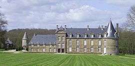
Le château | |
 Canisy | |
|
Location within Normandy region  Canisy | |
| Coordinates: 49°04′37″N 1°10′28″W / 49.0769°N 1.1744°WCoordinates: 49°04′37″N 1°10′28″W / 49.0769°N 1.1744°W | |
| Country | France |
| Region | Normandy |
| Department | Manche |
| Arrondissement | Saint-Lô |
| Canton | Canisy |
| Intercommunality | Communauté de communes du canton de Canisy |
| Government | |
| • Mayor (2008–2014) | Étienne Viard |
| Area1 | 6.25 km2 (2.41 sq mi) |
| Population (2006)2 | 1,024 |
| • Density | 160/km2 (420/sq mi) |
| Time zone | CET (UTC+1) |
| • Summer (DST) | CEST (UTC+2) |
| INSEE/Postal code | 50095 / 50750 |
| Elevation |
39–116 m (128–381 ft) (avg. 62 m or 203 ft) |
|
1 French Land Register data, which excludes lakes, ponds, glaciers > 1 km² (0.386 sq mi or 247 acres) and river estuaries. 2 Population without double counting: residents of multiple communes (e.g., students and military personnel) only counted once. | |
Canisy is a commune in the Manche department in Normandy in north-western France.
Heraldry
.svg.png) |
The arms of Canisy are blazoned : Vairy Or and gules, on a bend azure, a millrind between 2 horse-brays Or.
|
See also
| Wikimedia Commons has media related to Canisy. |
This article is issued from Wikipedia - version of the 7/5/2016. The text is available under the Creative Commons Attribution/Share Alike but additional terms may apply for the media files.