Cacoal
| Cacoal - Rondônia | |||
|---|---|---|---|
| Municipality | |||
| The Municipality of Cacoal | |||
|
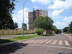
Guapore Avenue, Cacoal | |||
| |||
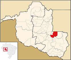 Location of Cacoal in the State of Rondônia | |||
| Coordinates: 11°26′19″S 61°26′50″W / 11.43861°S 61.44722°W | |||
| Country |
| ||
| Region | North | ||
| State |
| ||
| Founded | October 11, 1977 | ||
| Government | |||
| • Mayor | Francesco Vialetto PT | ||
| Area | |||
| • Total | 3,793 km2 (1,464 sq mi) | ||
| Elevation | 200 m (700 ft) | ||
| Population (2008)[1] | |||
| • Total | 78,263 | ||
| • Density | 19.7/km2 (51/sq mi) | ||
| Time zone | UTC-4 (UTC-4) | ||
| HDI (2000) | 0.755 – medium[2] | ||
| Website | www.cacoal.ro.gov.br | ||

Coordinates: 11°26′19″S 61°26′50″W / 11.43861°S 61.44722°W Cacoal is a municipality located in the Brazilian state of Rondônia. Its population as of 2008 was 78,263 and its area is 3,793 km².[3] It is the fourth-largest city in Rondônia state.
The city is served by Capital do Café Airport.
Climate
| Climate data for Cacoal | |||||||||||||
|---|---|---|---|---|---|---|---|---|---|---|---|---|---|
| Month | Jan | Feb | Mar | Apr | May | Jun | Jul | Aug | Sep | Oct | Nov | Dec | Year |
| Average high °C (°F) | 29.6 (85.3) |
29.2 (84.6) |
29.8 (85.6) |
29.6 (85.3) |
29.6 (85.3) |
30.5 (86.9) |
31.5 (88.7) |
33.3 (91.9) |
31.7 (89.1) |
30.9 (87.6) |
30.4 (86.7) |
30.0 (86) |
30.51 (86.92) |
| Daily mean °C (°F) | 23.9 (75) |
24.1 (75.4) |
24.3 (75.7) |
23.9 (75) |
23.7 (74.7) |
23.1 (73.6) |
23.0 (73.4) |
24.9 (76.8) |
24.5 (76.1) |
24.2 (75.6) |
24.1 (75.4) |
24.1 (75.4) |
23.98 (75.18) |
| Average low °C (°F) | 18.2 (64.8) |
19.1 (66.4) |
18.9 (66) |
18.2 (64.8) |
17.9 (64.2) |
15.7 (60.3) |
14.5 (58.1) |
16.5 (61.7) |
17.3 (63.1) |
17.6 (63.7) |
17.9 (64.2) |
18.2 (64.8) |
17.5 (63.51) |
| Average precipitation mm (inches) | 314 (12.36) |
293 (11.54) |
286 (11.26) |
172 (6.77) |
65 (2.56) |
15 (0.59) |
11 (0.43) |
27 (1.06) |
80 (3.15) |
141 (5.55) |
227 (8.94) |
268 (10.55) |
1,899 (74.76) |
| Source: http://en.climate-data.org/location/31797/ | |||||||||||||
External links
References
- ↑ - IBGE/2008
- ↑ "Archived copy". Archived from the original on 2009-10-03. Retrieved 2009-12-17. - UNDP
- ↑ "Archived copy". Archived from the original on 2008-06-11. Retrieved 2008-06-11. - IBGE
Capital: Porto Velho | ||
| Alvorada d'Oeste | 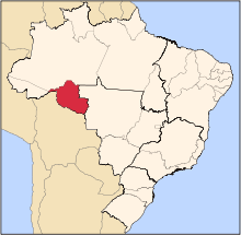 | |
| Ariquemes | ||
| Cacoal | ||
| Colorado do Oeste | ||
| Guajara-Mirim | ||
| Ji-Parana | ||
| Porto Velho | ||
| Vilhena | ||
This article is issued from Wikipedia - version of the 11/12/2016. The text is available under the Creative Commons Attribution/Share Alike but additional terms may apply for the media files.