Buritirama
| Buritirama Município de Buritirama | |
|---|---|
| Municipality | |
|
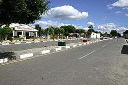
View of Buritirama | |
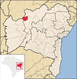 Location of Buritirama in Bahia | |
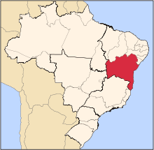
 Buritirama Location of Buritirama in the Brazil | |
| Coordinates: 10°42′28″S 43°37′51″W / 10.70778°S 43.63083°WCoordinates: 10°42′28″S 43°37′51″W / 10.70778°S 43.63083°W | |
| Country |
|
| Region | Northeast |
| State |
|
| Founded | 1986 |
| Government | |
| • Mayor | Arival Marques Viana (PP, 2013-2016) |
| Area | |
| • Total | 3,941.872 km2 (1,521.965 sq mi) |
| Elevation | 492 m (1,614 ft) |
| Population (2014) | |
| • Total | 21,418 |
| • Density | 5.4/km2 (14/sq mi) |
| Demonym(s) | buritiramense |
| Time zone | BRT (UTC-3) |
| Website |
pmburitirama |
Buritirama is a municipality in the state of Bahia in the North-East region of Brazil. Buritirama covers 3,941.872 km2 (1,521.965 sq mi), and has a population of 21,418 with a population density of 5.4 inhabitants per square kilometer.[1]
See also
References
- ↑ "Buritirama" (in Portuguese). Brasília, Brazil: Instituto Brasileiro de Geografia e Estatstica. 2015. Retrieved 2015-08-12.
This article is issued from Wikipedia - version of the 5/14/2016. The text is available under the Creative Commons Attribution/Share Alike but additional terms may apply for the media files.