Boevange-sur-Attert
| Boevange-sur-Attert Béiwen-Atert | ||
|---|---|---|
| Commune | ||
 | ||
| ||
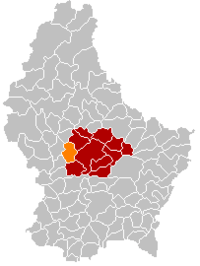 Map of Luxembourg with Boevange-sur-Attert highlighted in orange, and the canton in dark red | ||
| Coordinates: 49°47′00″N 6°01′00″E / 49.7833°N 6.0167°ECoordinates: 49°47′00″N 6°01′00″E / 49.7833°N 6.0167°E | ||
| Country |
| |
| Canton | Mersch | |
| Government | ||
| • Mayor | Paul Mangen | |
| Area | ||
| • Total | 12.31 km2 (4.75 sq mi) | |
| Area rank | 91st of 105 | |
| Highest elevation | 393 m (1,289 ft) | |
| • Rank | 56th of 105 | |
| Lowest elevation | 225 m (738 ft) | |
| • Rank | 39th of 105 | |
| Population (2014) | ||
| • Total | 2,250 | |
| • Rank | 60th of 105 | |
| • Density | 180/km2 (470/sq mi) | |
| • Density rank | 37th of 105 | |
| Time zone | CET (UTC+1) | |
| • Summer (DST) | CEST (UTC+2) | |
| LAU 2 | LU00012003 | |
| Website | boevange-attert.lu | |

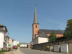
Boevange-sur-Attert (Luxembourgish: Béiwen-Atert, German: Böwingen) is a commune and small town in central Luxembourg, in the canton of Mersch. It is situated on the river Attert.
As of 2005, the town of Boevange-sur-Attert, which lies in the north of the commune, has a population of 554. Other towns within the commune include Brouch, Buschdorf, and Grevenknapp.
External links
-
 Media related to Boevange-sur-Attert at Wikimedia Commons
 |
Vichten (D) | Bissen | | |
| Useldange (D) | |
Mersch | ||
| ||||
| | ||||
| Saeul (D) | Tuntange |
 | ||
This article is issued from Wikipedia - version of the 12/1/2016. The text is available under the Creative Commons Attribution/Share Alike but additional terms may apply for the media files.