Bertrimont
| Bertrimont | ||
|---|---|---|
| ||
 Bertrimont | ||
|
Location within Normandy region  Bertrimont | ||
| Coordinates: 49°40′04″N 1°00′06″E / 49.6678°N 1.0017°ECoordinates: 49°40′04″N 1°00′06″E / 49.6678°N 1.0017°E | ||
| Country | France | |
| Region | Normandy | |
| Department | Seine-Maritime | |
| Arrondissement | Dieppe | |
| Canton | Tôtes | |
| Intercommunality | Trois Rivières | |
| Area1 | 4.74 km2 (1.83 sq mi) | |
| Population (2006)2 | 245 | |
| • Density | 52/km2 (130/sq mi) | |
| Time zone | CET (UTC+1) | |
| • Summer (DST) | CEST (UTC+2) | |
| INSEE/Postal code | 76086 / 76890 | |
| Elevation |
114–162 m (374–531 ft) (avg. 147 m or 482 ft) | |
|
1 French Land Register data, which excludes lakes, ponds, glaciers > 1 km² (0.386 sq mi or 247 acres) and river estuaries. 2 Population without double counting: residents of multiple communes (e.g., students and military personnel) only counted once. | ||
Bertrimont is a commune in the Seine-Maritime department in the Haute-Normandie region in northern France.
Geography
A small farming village in the Pays de Caux, situated some 20 miles (32 km) south of Dieppe, near the junction of the N29 and the D2 roads.
Heraldry
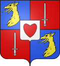 |
The arms of Bertrimont are blazoned : Quarterly 1&4: Azure, a griffon's head Or; 2&3: Gules, a sword argent; overall an inescutcheon Argent, a heart gules. |
Population
| Year | 1962 | 1968 | 1975 | 1982 | 1990 | 1999 | 2006 |
|---|---|---|---|---|---|---|---|
| Population | 95 | 125 | 117 | 115 | 124 | 195 | 245 |
| From the year 1962 on: No double counting—residents of multiple communes (e.g. students and military personnel) are counted only once. | |||||||
Places of interest
See also
References
External links
| Wikimedia Commons has media related to Bertrimont. |
- Bertrimont on the Quid website (French)
This article is issued from Wikipedia - version of the 10/31/2016. The text is available under the Creative Commons Attribution/Share Alike but additional terms may apply for the media files.