Arriana
| Arriana Αρριανά | |
|---|---|
|
Arriana municipality map. | |
 Arriana | |
|
Location within the region 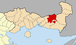 | |
| Coordinates: 41°05′N 25°42′E / 41.083°N 25.700°ECoordinates: 41°05′N 25°42′E / 41.083°N 25.700°E | |
| Country | Greece |
| Administrative region | East Macedonia and Thrace |
| Regional unit | Rhodope |
| Government | |
| • Mayor | Halit Mehmet |
| Area | |
| • Municipality | 768.9 km2 (296.9 sq mi) |
| Population (2011)[1] | |
| • Municipality | 16,577 |
| • Municipality density | 22/km2 (56/sq mi) |
| • Municipal unit | 5,589 |
| Community[1] | |
| • Population | 1,147 (2011) |
| Time zone | EET (UTC+2) |
| • Summer (DST) | EEST (UTC+3) |
| Vehicle registration | ΚΟ |

Arriana (Greek: Αρριανά, Turkish: Kozlubekir) is a municipality in the Rhodope regional unit, Greece. The seat of the municipality is in Fillyra.[2]
Municipality
The municipality Arriana was formed at the 2011 local government reform by the merger of the following 4 former municipalities, that became municipal units:[2]
References
- 1 2 "Απογραφή Πληθυσμού - Κατοικιών 2011. ΜΟΝΙΜΟΣ Πληθυσμός" (in Greek). Hellenic Statistical Authority.
- 1 2 Kallikratis law Greece Ministry of Interior (Greek)
Administrative division of the Eastern Macedonia and Thrace Region | ||
|---|---|---|
| Regional unit of Drama | 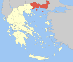 | |
| Regional unit of Evros | ||
| Regional unit of Kavala | ||
| Regional unit of Rhodope | ||
| Regional unit of Thasos | ||
| Regional unit of Xanthi | ||
| ||
This article is issued from Wikipedia - version of the 1/1/2016. The text is available under the Creative Commons Attribution/Share Alike but additional terms may apply for the media files.