Ardgarvan
| Ardgarvan Irish: Ard Garbháin[1] | |
|---|---|
| Irish transcription(s) | |
| • Derivation: | Ard Garbháin |
| • Meaning: | "Garvan's height" |
|
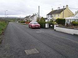
Ardgarvan in 2008 | |
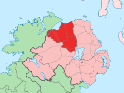
 Ardgarvan Ardgarvan shown within Northern Ireland | |
| Coordinates: 55°01′23″N 6°55′44″W / 55.023°N 6.929°WCoordinates: 55°01′23″N 6°55′44″W / 55.023°N 6.929°W | |
| Country | Northern Ireland |
| County | Londonderry |
| Barony | Keenaght |
| Civil parish | Drumcahose |
| Settlements | Ardgarvan |
| Government | |
| • Council | Causeway Coast and Glens |
| Area[2] | |
| • Total | 115.85 ha (286.27 acres) |
Ardgarvan (from Irish: Ard Garbháin, meaning "Garvan's height")[1] is a hamlet and townland in County Londonderry, Northern Ireland, 2 km south of Limavady. In the 2001 Census it had a population of 111 people. It is situated within Causeway Coast and Glens district.[3]
Features
The village has developed on the northern side of Ballyavelin Road and is dominated by public housing development. It has limited recreational facilities available to the local community.[3] Ardgarvan Post Office was one of 54 in Northern Ireland to be replaced by an outreach service before its demolition in 2009.[4]
See also
References
- 1 2 Placenames Database of Ireland
- ↑ Northern Ireland Environment Agency. "NIEA Map Viewer". Retrieved 27 January 2012.
- 1 2 "Ardgarvan Settlement Designation". Planning Service - Draft Northern Area Plan 2016. Retrieved 2008-06-23.
- ↑ "Ulster post offices affected by shake-up". Belfast Telegraph (3 June 2008). Retrieved 2008-06-23.
This article is issued from Wikipedia - version of the 9/7/2016. The text is available under the Creative Commons Attribution/Share Alike but additional terms may apply for the media files.