Arcola, Liguria
| Arcola | |
|---|---|
| Comune | |
| Comune di Arcola | |
|
Arcola | |
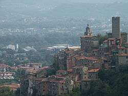
 Arcola Location of Arcola in Italy | |
| Coordinates: 44°7′N 9°54′E / 44.117°N 9.900°ECoordinates: 44°7′N 9°54′E / 44.117°N 9.900°E | |
| Country | Italy |
| Region | Liguria |
| Province / Metropolitan city | La Spezia (SP) |
| Frazioni | Baccano, Termo, Fresonara, Monti, Romito Magra, Cerri, Trebbiano |
| Area | |
| • Total | 16.4 km2 (6.3 sq mi) |
| Population (Dec. 2004) | |
| • Total | 10,145 |
| • Density | 620/km2 (1,600/sq mi) |
| Demonym(s) | Arcolani |
| Time zone | CET (UTC+1) |
| • Summer (DST) | CEST (UTC+2) |
| Postal code | 19021 |
| Dialing code | 0187 |
| Website | Official website |
Arcola is a comune (municipality) in the Province of La Spezia in the Italian region Liguria, located about 80 kilometres (50 mi) southeast of Genoa and about 7 kilometres (4 mi) northeast of La Spezia. As of 31 December 2004, it had a population of 10,145 and an area of 16.4 square kilometres (6.3 sq mi).[1]
The municipality of Arcola contains the frazioni (subdivisions, mainly villages and hamlets) Baccano, Termo, Fresonara, Monti, Romito Magra, Cerri, and Trebbiano.
Arcola borders the following municipalities: La Spezia, Lerici, Sarzana, Vezzano Ligure.
Demographic evolution

References
External links
This article is issued from Wikipedia - version of the 1/31/2015. The text is available under the Creative Commons Attribution/Share Alike but additional terms may apply for the media files.